You are here: Home > Network List > PF - Volcanologic Network of Piton de Fournaise-OVPF Stations List
> Station PRA Puys Ramond > Earthquake Result Viewer
PRA Puys Ramond - Earthquake Result Viewer
| Earthquake location: |
Iran-Iraq Border Region |
| Earthquake latitude/longitude: |
34.9/46.0 |
| Earthquake time(UTC): |
2017/11/12 (316) 18:18:17 GMT |
| Earthquake Depth: |
19 km |
| Earthquake Magnitude: |
7.3 Mww |
| Earthquake Catalog/Contributor: |
NEIC PDE/us |
|
| Network: |
PF Volcanologic Network of Piton de Fournaise-OVPF |
| Station: |
PRA Puys Ramond |
| Lat/Lon: |
21.29 S/55.71 E |
| Elevation: |
2009 m |
|
| Distance: |
56.6 deg |
| Az: |
169.1 deg |
| Baz: |
350.407 deg |
| Ray Param: |
0.06398232 |
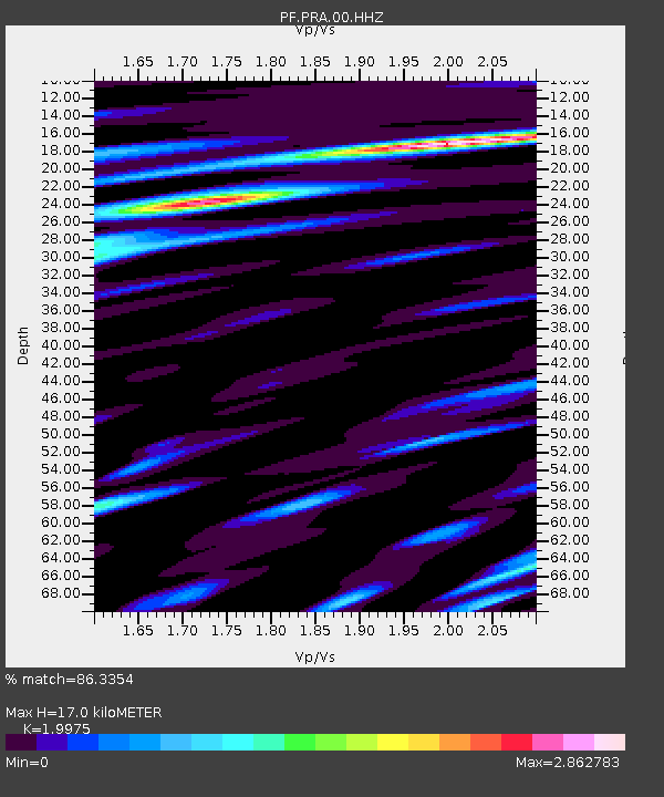
| Estimated Moho Depth: |
17.0 km |
| Estimated Crust Vp/Vs: |
2.00 |
| Assumed Crust Vp: |
4.73 km/s |
| Estimated Crust Vs: |
2.368 km/s |
| Estimated Crust Poisson's Ratio: |
0.33 |
|
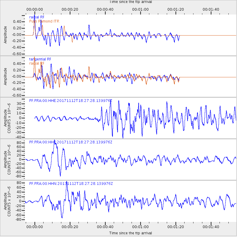
| Radial Match: |
86.3354 % |
| Radial Bump: |
400 |
| Transverse Match: |
76.50574 % |
| Transverse Bump: |
400 |
| SOD ConfigId: |
2429771 |
| Insert Time: |
2017-11-26 18:22:18.076 +0000 |
| GWidth: |
2.5 |
| Max Bumps: |
400 |
| Tol: |
0.001 |
|
Signal To Noise
| Channel | StoN | STA | LTA |
| PF:PRA:00:HHZ:20171112T18:27:28.139976Z | 18.658354 | 1.7996888E-5 | 9.645486E-7 |
| PF:PRA:00:HHN:20171112T18:27:28.139976Z | 4.570814 | 1.02877275E-5 | 2.250743E-6 |
| PF:PRA:00:HHE:20171112T18:27:28.139976Z | 0.48157212 | 1.3244886E-6 | 2.7503431E-6 |
| Arrivals |
| Ps | 3.7 SECOND |
| PpPs | 11 SECOND |
| PsPs/PpSs | 14 SECOND |


