You are here: Home > Network List > PF - Volcanologic Network of Piton de Fournaise-OVPF Stations List
> Station PRO La Providence (ONF) > Earthquake Result Viewer
PRO La Providence (ONF) - Earthquake Result Viewer
| Earthquake location: |
Iran-Iraq Border Region |
| Earthquake latitude/longitude: |
34.9/46.0 |
| Earthquake time(UTC): |
2017/11/12 (316) 18:18:17 GMT |
| Earthquake Depth: |
19 km |
| Earthquake Magnitude: |
7.3 Mww |
| Earthquake Catalog/Contributor: |
NEIC PDE/us |
|
| Network: |
PF Volcanologic Network of Piton de Fournaise-OVPF |
| Station: |
PRO La Providence (ONF) |
| Lat/Lon: |
20.90 S/55.45 E |
| Elevation: |
157 m |
|
| Distance: |
56.2 deg |
| Az: |
169.305 deg |
| Baz: |
350.611 deg |
| Ray Param: |
0.064259574 |
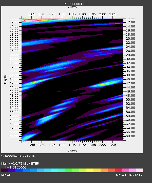
| Estimated Moho Depth: |
10.75 km |
| Estimated Crust Vp/Vs: |
1.61 |
| Assumed Crust Vp: |
4.73 km/s |
| Estimated Crust Vs: |
2.933 km/s |
| Estimated Crust Poisson's Ratio: |
0.19 |
|
| Radial Match: |
94.274284 % |
| Radial Bump: |
400 |
| Transverse Match: |
90.003426 % |
| Transverse Bump: |
400 |
| SOD ConfigId: |
2429771 |
| Insert Time: |
2017-11-26 18:22:18.935 +0000 |
| GWidth: |
2.5 |
| Max Bumps: |
400 |
| Tol: |
0.001 |
|
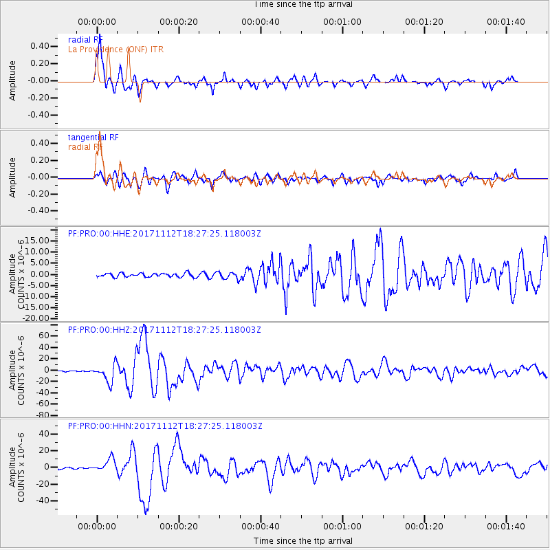
Signal To Noise
| Channel | StoN | STA | LTA |
| PF:PRO:00:HHZ:20171112T18:27:25.118003Z | 20.65595 | 1.6108908E-5 | 7.7986766E-7 |
| PF:PRO:00:HHN:20171112T18:27:25.118003Z | 8.514741 | 8.166202E-6 | 9.590664E-7 |
| PF:PRO:00:HHE:20171112T18:27:25.118003Z | 1.8714477 | 1.5779729E-6 | 8.4318293E-7 |
| Arrivals |
| Ps | 1.4 SECOND |
| PpPs | 5.8 SECOND |
| PsPs/PpSs | 7.2 SECOND |


