You are here: Home > Network List > PF - Volcanologic Network of Piton de Fournaise-OVPF Stations List
> Station SNE Station Sismologique de Soufriere nord est > Earthquake Result Viewer
SNE Station Sismologique de Soufriere nord est - Earthquake Result Viewer
| Earthquake location: |
Iran-Iraq Border Region |
| Earthquake latitude/longitude: |
34.9/46.0 |
| Earthquake time(UTC): |
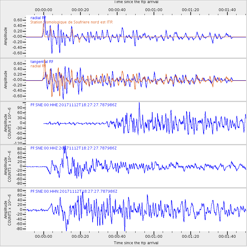
2017/11/12 (316) 18:18:17 GMT |
| Earthquake Depth: |
19 km |
| Earthquake Magnitude: |
7.3 Mww |
| Earthquake Catalog/Contributor: |
NEIC PDE/us |
|
| Network: |
PF Volcanologic Network of Piton de Fournaise-OVPF |
| Station: |
SNE Station Sismologique de Soufriere nord est |
| Lat/Lon: |
21.24 S/55.72 E |
| Elevation: |
2505 m |
|
| Distance: |
56.6 deg |
| Az: |
169.079 deg |
| Baz: |
350.391 deg |
| Ray Param: |
0.064015195 |
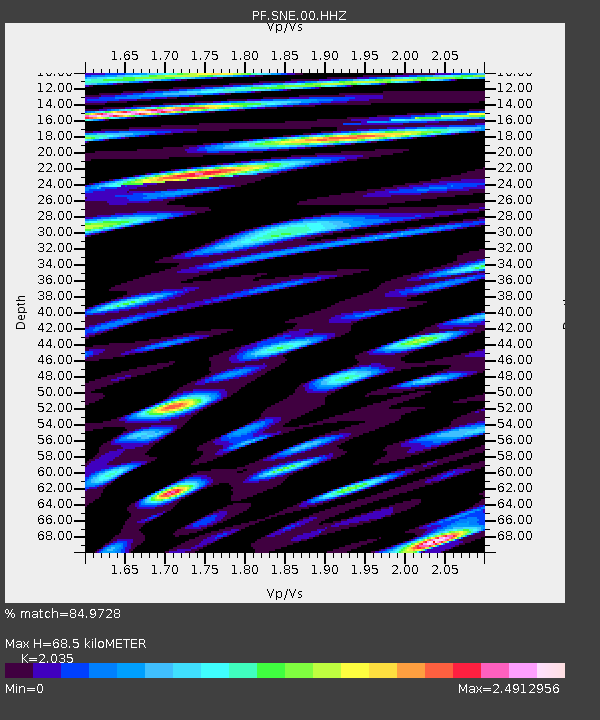
| Estimated Moho Depth: |
68.5 km |
| Estimated Crust Vp/Vs: |
2.04 |
| Assumed Crust Vp: |
4.73 km/s |
| Estimated Crust Vs: |
2.324 km/s |
| Estimated Crust Poisson's Ratio: |
0.34 |
|
| Radial Match: |
84.9728 % |
| Radial Bump: |
400 |
| Transverse Match: |
81.08347 % |
| Transverse Bump: |
400 |
| SOD ConfigId: |
2429771 |
| Insert Time: |
2017-11-26 18:22:22.897 +0000 |
| GWidth: |
2.5 |
| Max Bumps: |
400 |
| Tol: |
0.001 |
|
Signal To Noise
| Channel | StoN | STA | LTA |
| PF:SNE:00:HHZ:20171112T18:27:27.787986Z | 18.431414 | 1.5917818E-5 | 8.636243E-7 |
| PF:SNE:00:HHN:20171112T18:27:27.787986Z | 5.408472 | 1.0571974E-5 | 1.9547062E-6 |
| PF:SNE:00:HHE:20171112T18:27:27.787986Z | 1.3123513 | 4.1402272E-6 | 3.1548159E-6 |
| Arrivals |
| Ps | 15 SECOND |
| PpPs | 43 SECOND |
| PsPs/PpSs | 58 SECOND |


