You are here: Home > Network List > US - United States National Seismic Network Stations List
> Station CNNC Cliffs of the Neuse, North Carolina, USA > Earthquake Result Viewer
CNNC Cliffs of the Neuse, North Carolina, USA - Earthquake Result Viewer
| Earthquake location: |
Iran-Iraq Border Region |
| Earthquake latitude/longitude: |
34.9/46.0 |
| Earthquake time(UTC): |
2017/11/12 (316) 18:18:17 GMT |
| Earthquake Depth: |
19 km |
| Earthquake Magnitude: |
7.3 Mww |
| Earthquake Catalog/Contributor: |
NEIC PDE/us |
|
| Network: |
US United States National Seismic Network |
| Station: |
CNNC Cliffs of the Neuse, North Carolina, USA |
| Lat/Lon: |
35.24 N/77.88 W |
| Elevation: |
17 m |
|
| Distance: |
92.7 deg |
| Az: |
317.102 deg |
| Baz: |
43.115 deg |
| Ray Param: |
0.041399278 |
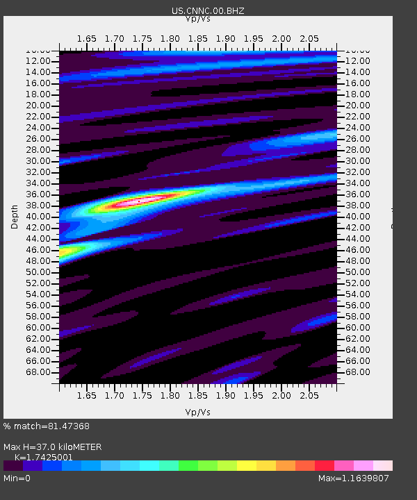
| Estimated Moho Depth: |
37.0 km |
| Estimated Crust Vp/Vs: |
1.74 |
| Assumed Crust Vp: |
6.565 km/s |
| Estimated Crust Vs: |
3.767 km/s |
| Estimated Crust Poisson's Ratio: |
0.25 |
|
| Radial Match: |
81.47368 % |
| Radial Bump: |
400 |
| Transverse Match: |
62.365555 % |
| Transverse Bump: |
400 |
| SOD ConfigId: |
2429771 |
| Insert Time: |
2017-11-26 18:22:44.280 +0000 |
| GWidth: |
2.5 |
| Max Bumps: |
400 |
| Tol: |
0.001 |
|
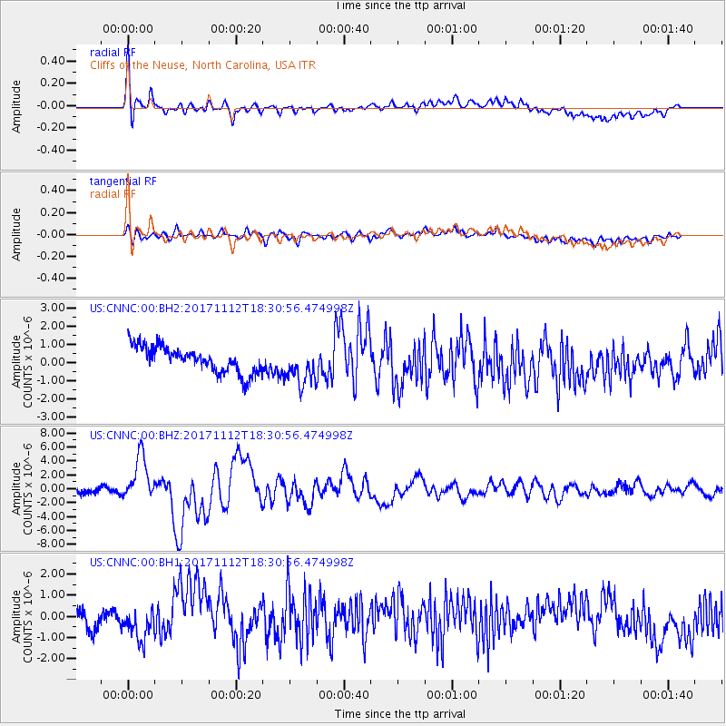
Signal To Noise
| Channel | StoN | STA | LTA |
| US:CNNC:00:BHZ:20171112T18:30:56.474998Z | 6.990419 | 3.3463866E-6 | 4.7871043E-7 |
| US:CNNC:00:BH1:20171112T18:30:56.474998Z | 1.6145443 | 7.204295E-7 | 4.462123E-7 |
| US:CNNC:00:BH2:20171112T18:30:56.474998Z | 1.4541862 | 1.0379537E-6 | 7.1376945E-7 |
| Arrivals |
| Ps | 4.3 SECOND |
| PpPs | 15 SECOND |
| PsPs/PpSs | 19 SECOND |


