You are here: Home > Network List > II - Global Seismograph Network (GSN - IRIS/IDA) Stations List
> Station XPFO Pinon Flat, California, USA > Earthquake Result Viewer
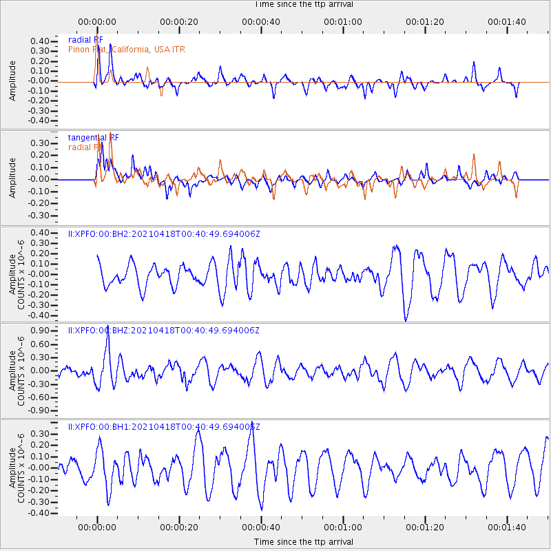
XPFO Pinon Flat, California, USA - Earthquake Result Viewer
*The percent match for this event was below the threshold and hence no stack was calculated.
| Earthquake location: |
Near East Coast Of Honshu, Japan |
| Earthquake latitude/longitude: |
38.3/141.8 |
| Earthquake time(UTC): |
2021/04/18 (108) 00:29:25 GMT |
| Earthquake Depth: |
31 km |
| Earthquake Magnitude: |
5.6 mb |
| Earthquake Catalog/Contributor: |
NEIC PDE/us |
|
| Network: |
II Global Seismograph Network (GSN - IRIS/IDA) |
| Station: |
XPFO Pinon Flat, California, USA |
| Lat/Lon: |
33.61 N/116.46 W |
| Elevation: |
1280 m |
|
| Distance: |
78.1 deg |
| Az: |
56.633 deg |
| Baz: |
308.028 deg |
| Ray Param: |
$rayparam |
*The percent match for this event was below the threshold and hence was not used in the summary stack. |
|
| Radial Match: |
63.900936 % |
| Radial Bump: |
400 |
| Transverse Match: |
56.150787 % |
| Transverse Bump: |
400 |
| SOD ConfigId: |
24334971 |
| Insert Time: |
2021-05-02 01:10:23.234 +0000 |
| GWidth: |
2.5 |
| Max Bumps: |
400 |
| Tol: |
0.001 |
|
Signal To Noise
| Channel | StoN | STA | LTA |
| II:XPFO:00:BHZ:20210418T00:40:49.694006Z | 2.178418 | 4.1634897E-7 | 1.9112447E-7 |
| II:XPFO:00:BH1:20210418T00:40:49.694006Z | 1.4930458 | 1.7254582E-7 | 1.1556632E-7 |
| II:XPFO:00:BH2:20210418T00:40:49.694006Z | 1.7290072 | 1.6586091E-7 | 9.592841E-8 |
| Arrivals |
| Ps | |
| PpPs | |
| PsPs/PpSs | |


