You are here: Home > Network List > IW - Intermountain West Stations List
> Station DLMT Dillon, Montana, USA > Earthquake Result Viewer
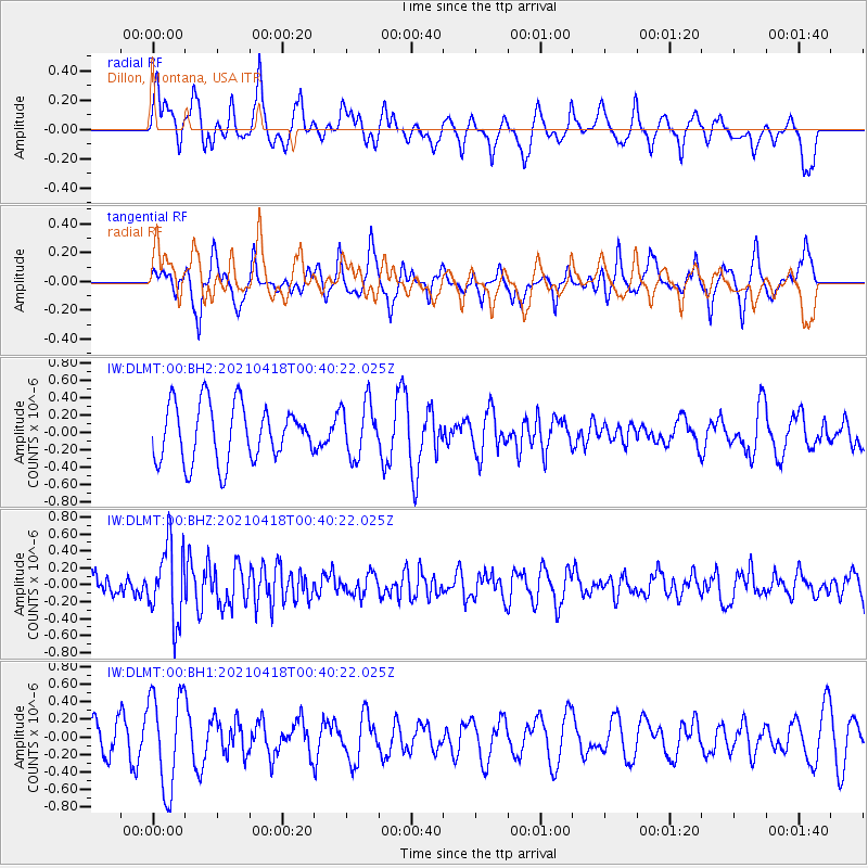
DLMT Dillon, Montana, USA - Earthquake Result Viewer
*The percent match for this event was below the threshold and hence no stack was calculated.
| Earthquake location: |
Near East Coast Of Honshu, Japan |
| Earthquake latitude/longitude: |
38.3/141.8 |
| Earthquake time(UTC): |
2021/04/18 (108) 00:29:25 GMT |
| Earthquake Depth: |
31 km |
| Earthquake Magnitude: |
5.6 mb |
| Earthquake Catalog/Contributor: |
NEIC PDE/us |
|
| Network: |
IW Intermountain West |
| Station: |
DLMT Dillon, Montana, USA |
| Lat/Lon: |
45.36 N/112.60 W |
| Elevation: |
1569 m |
|
| Distance: |
73.2 deg |
| Az: |
45.178 deg |
| Baz: |
307.636 deg |
| Ray Param: |
$rayparam |
*The percent match for this event was below the threshold and hence was not used in the summary stack. |
|
| Radial Match: |
61.795418 % |
| Radial Bump: |
400 |
| Transverse Match: |
62.720966 % |
| Transverse Bump: |
320 |
| SOD ConfigId: |
24334971 |
| Insert Time: |
2021-05-02 01:10:52.730 +0000 |
| GWidth: |
2.5 |
| Max Bumps: |
400 |
| Tol: |
0.001 |
|
Signal To Noise
| Channel | StoN | STA | LTA |
| IW:DLMT:00:BHZ:20210418T00:40:22.025Z | 2.9152908 | 4.4671413E-7 | 1.532314E-7 |
| IW:DLMT:00:BH1:20210418T00:40:22.025Z | 3.767255 | 5.4603913E-7 | 1.4494351E-7 |
| IW:DLMT:00:BH2:20210418T00:40:22.025Z | 0.9632369 | 3.1127442E-7 | 3.2315458E-7 |
| Arrivals |
| Ps | |
| PpPs | |
| PsPs/PpSs | |


