You are here: Home > Network List > IW - Intermountain West Stations List
> Station PLID Pearl Lake, Idaho, USA > Earthquake Result Viewer
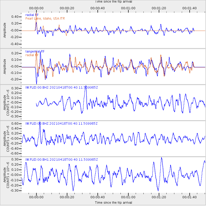
PLID Pearl Lake, Idaho, USA - Earthquake Result Viewer
*The percent match for this event was below the threshold and hence no stack was calculated.
| Earthquake location: |
Near East Coast Of Honshu, Japan |
| Earthquake latitude/longitude: |
38.3/141.8 |
| Earthquake time(UTC): |
2021/04/18 (108) 00:29:25 GMT |
| Earthquake Depth: |
31 km |
| Earthquake Magnitude: |
5.6 mb |
| Earthquake Catalog/Contributor: |
NEIC PDE/us |
|
| Network: |
IW Intermountain West |
| Station: |
PLID Pearl Lake, Idaho, USA |
| Lat/Lon: |
45.09 N/116.00 W |
| Elevation: |
2164 m |
|
| Distance: |
71.5 deg |
| Az: |
46.917 deg |
| Baz: |
305.755 deg |
| Ray Param: |
$rayparam |
*The percent match for this event was below the threshold and hence was not used in the summary stack. |
|
| Radial Match: |
39.11489 % |
| Radial Bump: |
339 |
| Transverse Match: |
67.58818 % |
| Transverse Bump: |
342 |
| SOD ConfigId: |
24334971 |
| Insert Time: |
2021-05-02 01:10:58.135 +0000 |
| GWidth: |
2.5 |
| Max Bumps: |
400 |
| Tol: |
0.001 |
|
Signal To Noise
| Channel | StoN | STA | LTA |
| IW:PLID:00:BHZ:20210418T00:40:11.509985Z | 2.1301305 | 2.8595835E-7 | 1.3424452E-7 |
| IW:PLID:00:BH1:20210418T00:40:11.509985Z | 0.9724037 | 1.1496274E-7 | 1.18225316E-7 |
| IW:PLID:00:BH2:20210418T00:40:11.509985Z | 2.7531633 | 1.7995356E-7 | 6.536247E-8 |
| Arrivals |
| Ps | |
| PpPs | |
| PsPs/PpSs | |


