You are here: Home > Network List > IW - Intermountain West Stations List
> Station MOOW Moose Ponds, Wyoming, USA > Earthquake Result Viewer
MOOW Moose Ponds, Wyoming, USA - Earthquake Result Viewer
| Earthquake location: |
Tonga Islands |
| Earthquake latitude/longitude: |
-21.9/-173.8 |
| Earthquake time(UTC): |
2008/10/19 (293) 05:10:33 GMT |
| Earthquake Depth: |
29 km |
| Earthquake Magnitude: |
6.8 MB, 7.0 MS, 6.9 MW, 6.9 MW |
| Earthquake Catalog/Contributor: |
WHDF/NEIC |
|
| Network: |
IW Intermountain West |
| Station: |
MOOW Moose Ponds, Wyoming, USA |
| Lat/Lon: |
43.75 N/110.74 W |
| Elevation: |
2128 m |
|
| Distance: |
87.1 deg |
| Az: |
40.311 deg |
| Baz: |
236.023 deg |
| Ray Param: |
0.043496765 |
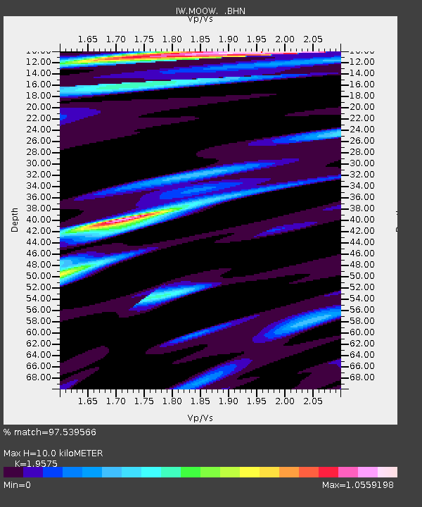
| Estimated Moho Depth: |
10.0 km |
| Estimated Crust Vp/Vs: |
1.96 |
| Assumed Crust Vp: |
6.207 km/s |
| Estimated Crust Vs: |
3.171 km/s |
| Estimated Crust Poisson's Ratio: |
0.32 |
|
| Radial Match: |
97.539566 % |
| Radial Bump: |
400 |
| Transverse Match: |
92.337425 % |
| Transverse Bump: |
400 |
| SOD ConfigId: |
2556 |
| Insert Time: |
2010-03-09 07:23:51.116 +0000 |
| GWidth: |
2.5 |
| Max Bumps: |
400 |
| Tol: |
0.001 |
|

Signal To Noise
| Channel | StoN | STA | LTA |
| IW:MOOW: :BHN:20081019T05:22:45.790005Z | 26.598993 | 4.2760057E-6 | 1.6075818E-7 |
| IW:MOOW: :BHE:20081019T05:22:45.790005Z | 9.526387 | 1.022976E-6 | 1.07383414E-7 |
| IW:MOOW: :BHZ:20081019T05:22:45.790005Z | 8.92265 | 8.564043E-7 | 9.598093E-8 |
| Arrivals |
| Ps | 1.6 SECOND |
| PpPs | 4.7 SECOND |
| PsPs/PpSs | 6.2 SECOND |


