You are here: Home > Network List > IW - Intermountain West Stations List
> Station MOOW Moose Ponds, Wyoming, USA > Earthquake Result Viewer
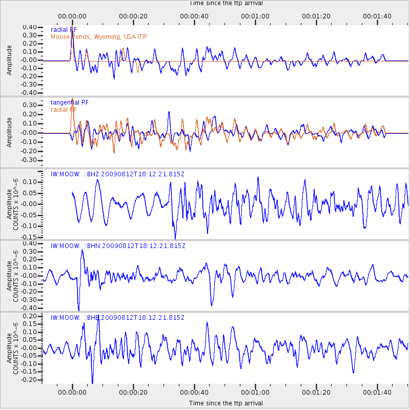
MOOW Moose Ponds, Wyoming, USA - Earthquake Result Viewer
*The percent match for this event was below the threshold and hence no stack was calculated.
| Earthquake location: |
Catamarca Province, Argentina |
| Earthquake latitude/longitude: |
-27.9/-66.7 |
| Earthquake time(UTC): |
2009/08/12 (224) 18:00:52 GMT |
| Earthquake Depth: |
174 km |
| Earthquake Magnitude: |
5.5 MW, 5.3 MB, 5.5 MW |
| Earthquake Catalog/Contributor: |
WHDF/NEIC |
|
| Network: |
IW Intermountain West |
| Station: |
MOOW Moose Ponds, Wyoming, USA |
| Lat/Lon: |
43.75 N/110.74 W |
| Elevation: |
2128 m |
|
| Distance: |
81.9 deg |
| Az: |
329.396 deg |
| Baz: |
141.552 deg |
| Ray Param: |
$rayparam |
*The percent match for this event was below the threshold and hence was not used in the summary stack. |
|
| Radial Match: |
69.55178 % |
| Radial Bump: |
400 |
| Transverse Match: |
51.956463 % |
| Transverse Bump: |
400 |
| SOD ConfigId: |
2622 |
| Insert Time: |
2010-03-09 07:23:55.684 +0000 |
| GWidth: |
2.5 |
| Max Bumps: |
400 |
| Tol: |
0.001 |
|
Signal To Noise
| Channel | StoN | STA | LTA |
| IW:MOOW: :BHN:20090812T18:12:21.815Z | 3.7990432 | 1.8053933E-7 | 4.7522317E-8 |
| IW:MOOW: :BHE:20090812T18:12:21.815Z | 1.8171281 | 6.3201306E-8 | 3.478088E-8 |
| IW:MOOW: :BHZ:20090812T18:12:21.815Z | 1.4054126 | 6.5039E-8 | 4.6277517E-8 |
| Arrivals |
| Ps | |
| PpPs | |
| PsPs/PpSs | |


