You are here: Home > Network List > IW - Intermountain West Stations List
> Station MOOW Moose Ponds, Wyoming, USA > Earthquake Result Viewer
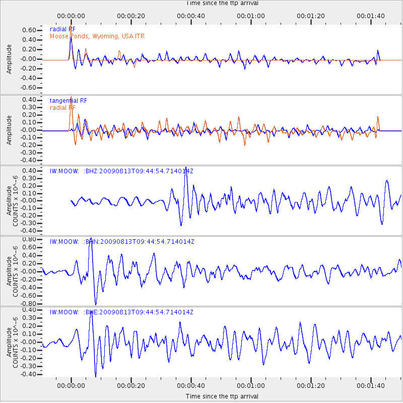
MOOW Moose Ponds, Wyoming, USA - Earthquake Result Viewer
*The percent match for this event was below the threshold and hence no stack was calculated.
| Earthquake location: |
Off Coast Of Costa Rica |
| Earthquake latitude/longitude: |
7.9/-85.6 |
| Earthquake time(UTC): |
2009/08/13 (225) 09:37:35 GMT |
| Earthquake Depth: |
10 km |
| Earthquake Magnitude: |
5.8 MW, 5.3 MB |
| Earthquake Catalog/Contributor: |
WHDF/NEIC |
|
| Network: |
IW Intermountain West |
| Station: |
MOOW Moose Ponds, Wyoming, USA |
| Lat/Lon: |
43.75 N/110.74 W |
| Elevation: |
2128 m |
|
| Distance: |
41.9 deg |
| Az: |
332.563 deg |
| Baz: |
140.966 deg |
| Ray Param: |
$rayparam |
*The percent match for this event was below the threshold and hence was not used in the summary stack. |
|
| Radial Match: |
79.99576 % |
| Radial Bump: |
400 |
| Transverse Match: |
64.1044 % |
| Transverse Bump: |
297 |
| SOD ConfigId: |
2622 |
| Insert Time: |
2010-03-09 07:23:56.504 +0000 |
| GWidth: |
2.5 |
| Max Bumps: |
400 |
| Tol: |
0.001 |
|
Signal To Noise
| Channel | StoN | STA | LTA |
| IW:MOOW: :BHN:20090813T09:44:54.714014Z | 3.9038634 | 1.5540824E-7 | 3.9808832E-8 |
| IW:MOOW: :BHE:20090813T09:44:54.714014Z | 3.1062858 | 1.1292657E-7 | 3.6354212E-8 |
| IW:MOOW: :BHZ:20090813T09:44:54.714014Z | 2.112001 | 7.600799E-8 | 3.5988617E-8 |
| Arrivals |
| Ps | |
| PpPs | |
| PsPs/PpSs | |


