You are here: Home > Network List > IW - Intermountain West Stations List
> Station MOOW Moose Ponds, Wyoming, USA > Earthquake Result Viewer
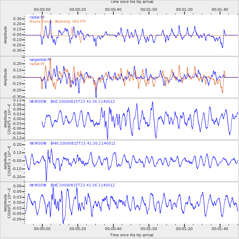
MOOW Moose Ponds, Wyoming, USA - Earthquake Result Viewer
*The percent match for this event was below the threshold and hence no stack was calculated.
| Earthquake location: |
Fiji Islands Region |
| Earthquake latitude/longitude: |
-19.8/-178.2 |
| Earthquake time(UTC): |
2009/08/15 (227) 23:30:19 GMT |
| Earthquake Depth: |
608 km |
| Earthquake Magnitude: |
5.6 MW, 5.2 MB |
| Earthquake Catalog/Contributor: |
WHDF/NEIC |
|
| Network: |
IW Intermountain West |
| Station: |
MOOW Moose Ponds, Wyoming, USA |
| Lat/Lon: |
43.75 N/110.74 W |
| Elevation: |
2128 m |
|
| Distance: |
88.3 deg |
| Az: |
42.05 deg |
| Baz: |
240.472 deg |
| Ray Param: |
$rayparam |
*The percent match for this event was below the threshold and hence was not used in the summary stack. |
|
| Radial Match: |
60.356228 % |
| Radial Bump: |
400 |
| Transverse Match: |
56.467724 % |
| Transverse Bump: |
400 |
| SOD ConfigId: |
2622 |
| Insert Time: |
2010-03-09 07:23:57.369 +0000 |
| GWidth: |
2.5 |
| Max Bumps: |
400 |
| Tol: |
0.001 |
|
Signal To Noise
| Channel | StoN | STA | LTA |
| IW:MOOW: :BHN:20090815T23:41:36.214001Z | 1.7155172 | 8.4127215E-8 | 4.903898E-8 |
| IW:MOOW: :BHE:20090815T23:41:36.214001Z | 1.0148475 | 3.315132E-8 | 3.2666307E-8 |
| IW:MOOW: :BHZ:20090815T23:41:36.214001Z | 1.2023448 | 3.4473736E-8 | 2.8672089E-8 |
| Arrivals |
| Ps | |
| PpPs | |
| PsPs/PpSs | |


