You are here: Home > Network List > IW - Intermountain West Stations List
> Station MOOW Moose Ponds, Wyoming, USA > Earthquake Result Viewer
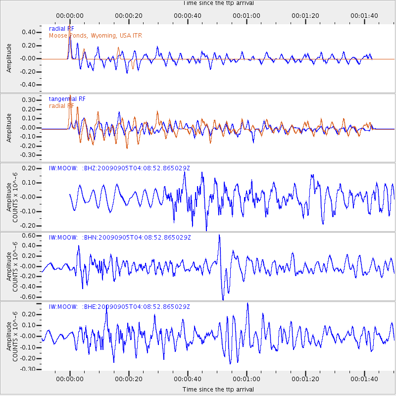
MOOW Moose Ponds, Wyoming, USA - Earthquake Result Viewer
*The percent match for this event was below the threshold and hence no stack was calculated.
| Earthquake location: |
Southern Peru |
| Earthquake latitude/longitude: |
-15.1/-70.2 |
| Earthquake time(UTC): |
2009/09/05 (248) 03:58:39 GMT |
| Earthquake Depth: |
210 km |
| Earthquake Magnitude: |
5.8 MW, 5.2 MB, 5.8 MW |
| Earthquake Catalog/Contributor: |
WHDF/NEIC |
|
| Network: |
IW Intermountain West |
| Station: |
MOOW Moose Ponds, Wyoming, USA |
| Lat/Lon: |
43.75 N/110.74 W |
| Elevation: |
2128 m |
|
| Distance: |
69.3 deg |
| Az: |
329.793 deg |
| Baz: |
137.892 deg |
| Ray Param: |
$rayparam |
*The percent match for this event was below the threshold and hence was not used in the summary stack. |
|
| Radial Match: |
62.51547 % |
| Radial Bump: |
298 |
| Transverse Match: |
65.885956 % |
| Transverse Bump: |
400 |
| SOD ConfigId: |
2622 |
| Insert Time: |
2010-03-09 07:24:00.143 +0000 |
| GWidth: |
2.5 |
| Max Bumps: |
400 |
| Tol: |
0.001 |
|
Signal To Noise
| Channel | StoN | STA | LTA |
| IW:MOOW: :BHN:20090905T04:08:52.865029Z | 3.298847 | 1.7052585E-7 | 5.169256E-8 |
| IW:MOOW: :BHE:20090905T04:08:52.865029Z | 1.1830348 | 5.521549E-8 | 4.6672753E-8 |
| IW:MOOW: :BHZ:20090905T04:08:52.865029Z | 0.7777311 | 3.7966576E-8 | 4.88171E-8 |
| Arrivals |
| Ps | |
| PpPs | |
| PsPs/PpSs | |


