You are here: Home > Network List > TA - USArray Transportable Network (new EarthScope stations) Stations List
> Station F26K Sheenjek River, AK, USA > Earthquake Result Viewer
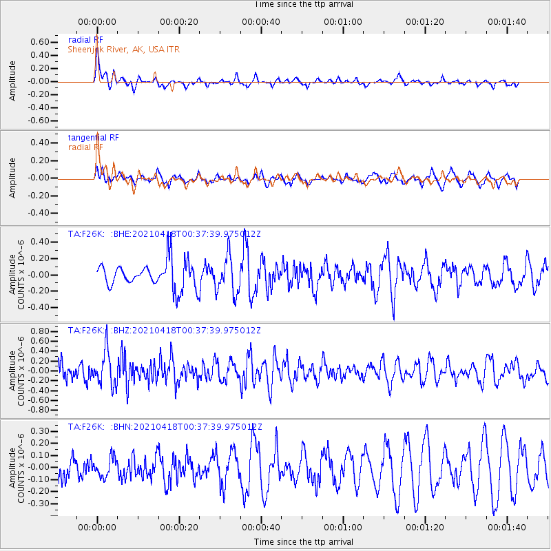
F26K Sheenjek River, AK, USA - Earthquake Result Viewer
*The percent match for this event was below the threshold and hence no stack was calculated.
| Earthquake location: |
Near East Coast Of Honshu, Japan |
| Earthquake latitude/longitude: |
38.3/141.8 |
| Earthquake time(UTC): |
2021/04/18 (108) 00:29:25 GMT |
| Earthquake Depth: |
31 km |
| Earthquake Magnitude: |
5.6 mb |
| Earthquake Catalog/Contributor: |
NEIC PDE/us |
|
| Network: |
TA USArray Transportable Network (new EarthScope stations) |
| Station: |
F26K Sheenjek River, AK, USA |
| Lat/Lon: |
67.69 N/144.15 W |
| Elevation: |
683 m |
|
| Distance: |
49.2 deg |
| Az: |
28.977 deg |
| Baz: |
272.661 deg |
| Ray Param: |
$rayparam |
*The percent match for this event was below the threshold and hence was not used in the summary stack. |
|
| Radial Match: |
55.356388 % |
| Radial Bump: |
380 |
| Transverse Match: |
40.051212 % |
| Transverse Bump: |
400 |
| SOD ConfigId: |
24334971 |
| Insert Time: |
2021-05-02 01:18:49.074 +0000 |
| GWidth: |
2.5 |
| Max Bumps: |
400 |
| Tol: |
0.001 |
|
Signal To Noise
| Channel | StoN | STA | LTA |
| TA:F26K: :BHZ:20210418T00:37:39.975012Z | 1.3306415 | 3.635433E-7 | 2.7320905E-7 |
| TA:F26K: :BHN:20210418T00:37:39.975012Z | 1.02383 | 8.051434E-8 | 7.864034E-8 |
| TA:F26K: :BHE:20210418T00:37:39.975012Z | 1.5026042 | 2.3585154E-7 | 1.5696185E-7 |
| Arrivals |
| Ps | |
| PpPs | |
| PsPs/PpSs | |


