You are here: Home > Network List > TA - USArray Transportable Network (new EarthScope stations) Stations List
> Station G31M Satah River, YT, CAN > Earthquake Result Viewer
G31M Satah River, YT, CAN - Earthquake Result Viewer
*The percent match for this event was below the threshold and hence no stack was calculated.
| Earthquake location: |
Near East Coast Of Honshu, Japan |
| Earthquake latitude/longitude: |
38.3/141.8 |
| Earthquake time(UTC): |
2021/04/18 (108) 00:29:25 GMT |
| Earthquake Depth: |
31 km |
| Earthquake Magnitude: |
5.6 mb |
| Earthquake Catalog/Contributor: |
NEIC PDE/us |
|
| Network: |
TA USArray Transportable Network (new EarthScope stations) |
| Station: |
G31M Satah River, YT, CAN |
| Lat/Lon: |
66.92 N/134.27 W |
| Elevation: |
61 m |
|
| Distance: |
53.1 deg |
| Az: |
29.334 deg |
| Baz: |
281.99 deg |
| Ray Param: |
$rayparam |
*The percent match for this event was below the threshold and hence was not used in the summary stack. |
|
| Radial Match: |
79.663925 % |
| Radial Bump: |
400 |
| Transverse Match: |
51.54035 % |
| Transverse Bump: |
361 |
| SOD ConfigId: |
24334971 |
| Insert Time: |
2021-05-02 01:19:03.661 +0000 |
| GWidth: |
2.5 |
| Max Bumps: |
400 |
| Tol: |
0.001 |
|
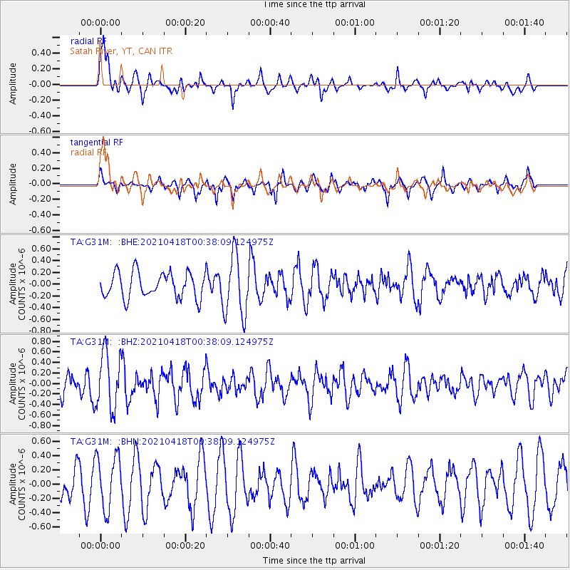
Signal To Noise
| Channel | StoN | STA | LTA |
| TA:G31M: :BHZ:20210418T00:38:09.124975Z | 2.4029732 | 5.4692885E-7 | 2.2760506E-7 |
| TA:G31M: :BHN:20210418T00:38:09.124975Z | 0.98559076 | 3.763862E-7 | 3.8188892E-7 |
| TA:G31M: :BHE:20210418T00:38:09.124975Z | 2.4439127 | 5.275234E-7 | 2.15852E-7 |
| Arrivals |
| Ps | |
| PpPs | |
| PsPs/PpSs | |


