You are here: Home > Network List > IW - Intermountain West Stations List
> Station MOOW Moose Ponds, Wyoming, USA > Earthquake Result Viewer
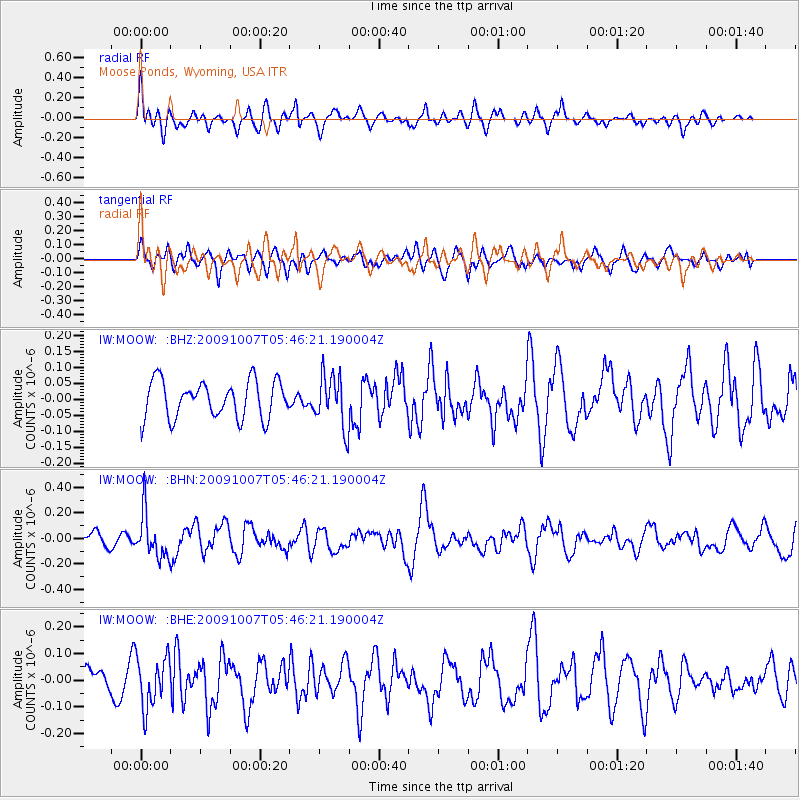
MOOW Moose Ponds, Wyoming, USA - Earthquake Result Viewer
*The percent match for this event was below the threshold and hence no stack was calculated.
| Earthquake location: |
Rat Islands, Aleutian Islands |
| Earthquake latitude/longitude: |
52.2/178.1 |
| Earthquake time(UTC): |
2009/10/07 (280) 05:38:37 GMT |
| Earthquake Depth: |
138 km |
| Earthquake Magnitude: |
5.6 MB, 5.6 MW, 5.6 MW |
| Earthquake Catalog/Contributor: |
WHDF/NEIC |
|
| Network: |
IW Intermountain West |
| Station: |
MOOW Moose Ponds, Wyoming, USA |
| Lat/Lon: |
43.75 N/110.74 W |
| Elevation: |
2128 m |
|
| Distance: |
46.6 deg |
| Az: |
70.675 deg |
| Baz: |
306.658 deg |
| Ray Param: |
$rayparam |
*The percent match for this event was below the threshold and hence was not used in the summary stack. |
|
| Radial Match: |
63.476105 % |
| Radial Bump: |
400 |
| Transverse Match: |
51.92904 % |
| Transverse Bump: |
400 |
| SOD ConfigId: |
2622 |
| Insert Time: |
2010-03-09 07:24:05.332 +0000 |
| GWidth: |
2.5 |
| Max Bumps: |
400 |
| Tol: |
0.001 |
|
Signal To Noise
| Channel | StoN | STA | LTA |
| IW:MOOW: :BHN:20091007T05:46:21.190004Z | 2.3702528 | 1.7240154E-7 | 7.27355E-8 |
| IW:MOOW: :BHE:20091007T05:46:21.190004Z | 1.9655064 | 9.380102E-8 | 4.772359E-8 |
| IW:MOOW: :BHZ:20091007T05:46:21.190004Z | 1.4120729 | 8.1305934E-8 | 5.7579136E-8 |
| Arrivals |
| Ps | |
| PpPs | |
| PsPs/PpSs | |


