You are here: Home > Network List > TA - USArray Transportable Network (new EarthScope stations) Stations List
> Station O28M Mount Upton, YT, CAN > Earthquake Result Viewer
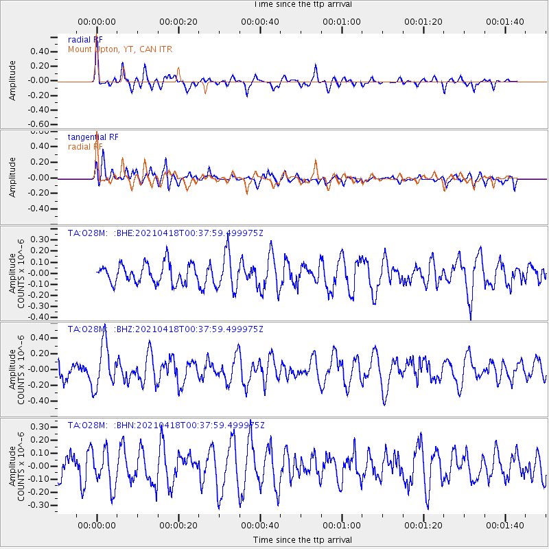
O28M Mount Upton, YT, CAN - Earthquake Result Viewer
*The percent match for this event was below the threshold and hence no stack was calculated.
| Earthquake location: |
Near East Coast Of Honshu, Japan |
| Earthquake latitude/longitude: |
38.3/141.8 |
| Earthquake time(UTC): |
2021/04/18 (108) 00:29:25 GMT |
| Earthquake Depth: |
31 km |
| Earthquake Magnitude: |
5.6 mb |
| Earthquake Catalog/Contributor: |
NEIC PDE/us |
|
| Network: |
TA USArray Transportable Network (new EarthScope stations) |
| Station: |
O28M Mount Upton, YT, CAN |
| Lat/Lon: |
60.77 N/140.19 W |
| Elevation: |
2622 m |
|
| Distance: |
51.8 deg |
| Az: |
37.626 deg |
| Baz: |
281.73 deg |
| Ray Param: |
$rayparam |
*The percent match for this event was below the threshold and hence was not used in the summary stack. |
|
| Radial Match: |
68.79126 % |
| Radial Bump: |
400 |
| Transverse Match: |
47.673325 % |
| Transverse Bump: |
400 |
| SOD ConfigId: |
24334971 |
| Insert Time: |
2021-05-02 01:19:48.506 +0000 |
| GWidth: |
2.5 |
| Max Bumps: |
400 |
| Tol: |
0.001 |
|
Signal To Noise
| Channel | StoN | STA | LTA |
| TA:O28M: :BHZ:20210418T00:37:59.499975Z | 2.3629403 | 2.8641634E-7 | 1.2121183E-7 |
| TA:O28M: :BHN:20210418T00:37:59.499975Z | 1.4529792 | 1.417411E-7 | 9.755205E-8 |
| TA:O28M: :BHE:20210418T00:37:59.499975Z | 1.939773 | 1.665072E-7 | 8.583851E-8 |
| Arrivals |
| Ps | |
| PpPs | |
| PsPs/PpSs | |


