You are here: Home > Network List > WI - West Indies IPGP Network Stations List
> Station CBE Capesterre Belles-Eaux, Guadeloupe > Earthquake Result Viewer
CBE Capesterre Belles-Eaux, Guadeloupe - Earthquake Result Viewer
| Earthquake location: |
Iran-Iraq Border Region |
| Earthquake latitude/longitude: |
34.9/46.0 |
| Earthquake time(UTC): |
2017/11/12 (316) 18:18:17 GMT |
| Earthquake Depth: |
19 km |
| Earthquake Magnitude: |
7.3 Mww |
| Earthquake Catalog/Contributor: |
NEIC PDE/us |
|
| Network: |
WI West Indies IPGP Network |
| Station: |
CBE Capesterre Belles-Eaux, Guadeloupe |
| Lat/Lon: |
16.07 N/61.61 W |
| Elevation: |
380 m |
|
| Distance: |
94.7 deg |
| Az: |
293.121 deg |
| Baz: |
51.832 deg |
| Ray Param: |
0.04097477 |
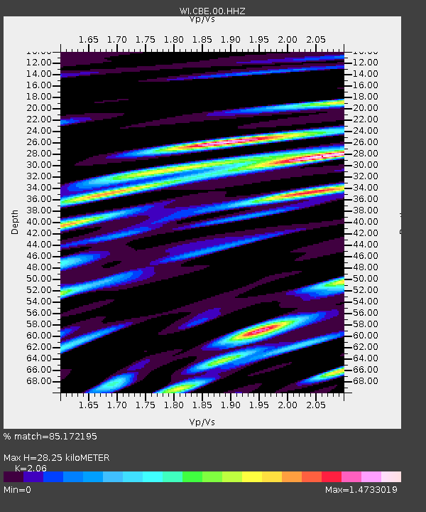
| Estimated Moho Depth: |
28.25 km |
| Estimated Crust Vp/Vs: |
2.06 |
| Assumed Crust Vp: |
6.048 km/s |
| Estimated Crust Vs: |
2.936 km/s |
| Estimated Crust Poisson's Ratio: |
0.35 |
|
| Radial Match: |
85.172195 % |
| Radial Bump: |
400 |
| Transverse Match: |
72.839226 % |
| Transverse Bump: |
400 |
| SOD ConfigId: |
2429771 |
| Insert Time: |
2017-11-26 18:23:23.552 +0000 |
| GWidth: |
2.5 |
| Max Bumps: |
400 |
| Tol: |
0.001 |
|

Signal To Noise
| Channel | StoN | STA | LTA |
| WI:CBE:00:HHZ:20171112T18:31:05.480002Z | 5.199212 | 2.4031451E-6 | 4.6221334E-7 |
| WI:CBE:00:HHN:20171112T18:31:05.480002Z | 1.287574 | 9.871617E-7 | 7.6668346E-7 |
| WI:CBE:00:HHE:20171112T18:31:05.480002Z | 1.9311932 | 1.248714E-6 | 6.4660236E-7 |
| Arrivals |
| Ps | 5.0 SECOND |
| PpPs | 14 SECOND |
| PsPs/PpSs | 19 SECOND |


