You are here: Home > Network List > US - United States National Seismic Network Stations List
> Station CBKS Cedar Bluff, Kansas, USA > Earthquake Result Viewer
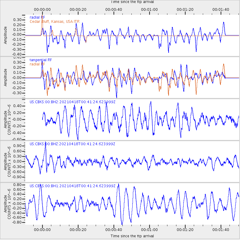
CBKS Cedar Bluff, Kansas, USA - Earthquake Result Viewer
*The percent match for this event was below the threshold and hence no stack was calculated.
| Earthquake location: |
Near East Coast Of Honshu, Japan |
| Earthquake latitude/longitude: |
38.3/141.8 |
| Earthquake time(UTC): |
2021/04/18 (108) 00:29:25 GMT |
| Earthquake Depth: |
31 km |
| Earthquake Magnitude: |
5.6 mb |
| Earthquake Catalog/Contributor: |
NEIC PDE/us |
|
| Network: |
US United States National Seismic Network |
| Station: |
CBKS Cedar Bluff, Kansas, USA |
| Lat/Lon: |
38.81 N/99.74 W |
| Elevation: |
677 m |
|
| Distance: |
84.7 deg |
| Az: |
43.628 deg |
| Baz: |
315.959 deg |
| Ray Param: |
$rayparam |
*The percent match for this event was below the threshold and hence was not used in the summary stack. |
|
| Radial Match: |
67.66082 % |
| Radial Bump: |
400 |
| Transverse Match: |
58.27088 % |
| Transverse Bump: |
400 |
| SOD ConfigId: |
24334971 |
| Insert Time: |
2021-05-02 01:21:44.210 +0000 |
| GWidth: |
2.5 |
| Max Bumps: |
400 |
| Tol: |
0.001 |
|
Signal To Noise
| Channel | StoN | STA | LTA |
| US:CBKS:00:BHZ:20210418T00:41:24.623999Z | 1.8664217 | 4.4307805E-7 | 2.373944E-7 |
| US:CBKS:00:BH1:20210418T00:41:24.623999Z | 1.1541737 | 4.0342672E-7 | 3.495373E-7 |
| US:CBKS:00:BH2:20210418T00:41:24.623999Z | 1.0088651 | 2.3527745E-7 | 2.3321E-7 |
| Arrivals |
| Ps | |
| PpPs | |
| PsPs/PpSs | |


