You are here: Home > Network List > IW - Intermountain West Stations List
> Station MOOW Moose Ponds, Wyoming, USA > Earthquake Result Viewer
MOOW Moose Ponds, Wyoming, USA - Earthquake Result Viewer
*The percent match for this event was below the threshold and hence no stack was calculated.
| Earthquake location: |
Kermadec Islands Region |
| Earthquake latitude/longitude: |
-31.2/-176.9 |
| Earthquake time(UTC): |
2008/12/09 (344) 06:23:59 GMT |
| Earthquake Depth: |
18 km |
| Earthquake Magnitude: |
6.2 MB, 6.7 MS, 6.8 MW, 6.7 MW |
| Earthquake Catalog/Contributor: |
WHDF/NEIC |
|
| Network: |
IW Intermountain West |
| Station: |
MOOW Moose Ponds, Wyoming, USA |
| Lat/Lon: |
43.75 N/110.74 W |
| Elevation: |
2128 m |
|
| Distance: |
96.0 deg |
| Az: |
41.808 deg |
| Baz: |
231.997 deg |
| Ray Param: |
$rayparam |
*The percent match for this event was below the threshold and hence was not used in the summary stack. |
|
| Radial Match: |
68.31384 % |
| Radial Bump: |
394 |
| Transverse Match: |
48.6231 % |
| Transverse Bump: |
400 |
| SOD ConfigId: |
2658 |
| Insert Time: |
2010-03-09 07:24:25.095 +0000 |
| GWidth: |
2.5 |
| Max Bumps: |
400 |
| Tol: |
0.001 |
|
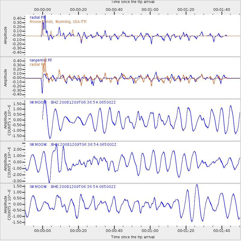
Signal To Noise
| Channel | StoN | STA | LTA |
| IW:MOOW: :BHN:20081209T06:36:54.065002Z | 2.2755063 | 1.6793656E-6 | 7.3801846E-7 |
| IW:MOOW: :BHE:20081209T06:36:54.065002Z | 0.3456712 | 2.2430568E-7 | 6.4889895E-7 |
| IW:MOOW: :BHZ:20081209T06:36:54.065002Z | 1.1771976 | 8.5338587E-7 | 7.2493003E-7 |
| Arrivals |
| Ps | |
| PpPs | |
| PsPs/PpSs | |


