You are here: Home > Network List > IW - Intermountain West Stations List
> Station MOOW Moose Ponds, Wyoming, USA > Earthquake Result Viewer
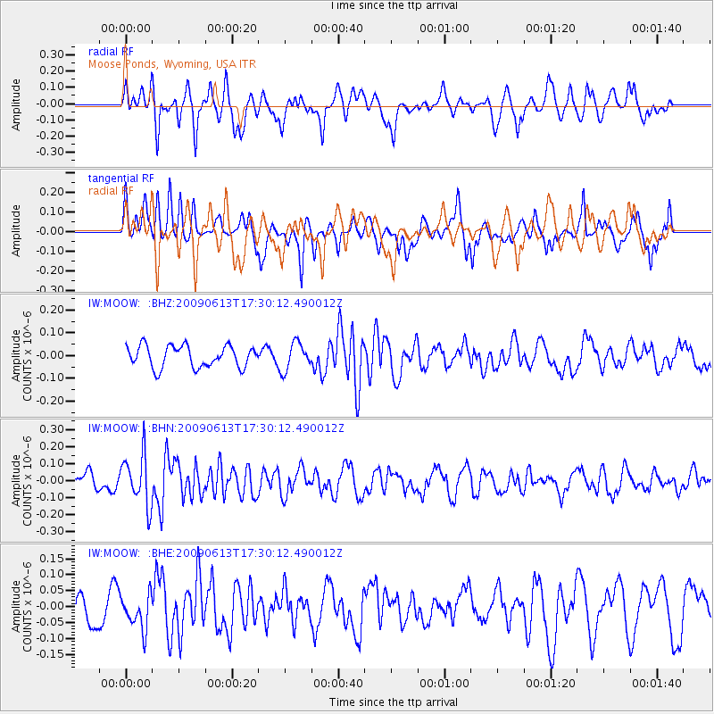
MOOW Moose Ponds, Wyoming, USA - Earthquake Result Viewer
*The percent match for this event was below the threshold and hence no stack was calculated.
| Earthquake location: |
Eastern Kazakhstan |
| Earthquake latitude/longitude: |
44.7/78.9 |
| Earthquake time(UTC): |
2009/06/13 (164) 17:17:38 GMT |
| Earthquake Depth: |
14 km |
| Earthquake Magnitude: |
5.8 MB, 5.1 MS, 5.4 MW, 5.4 MW |
| Earthquake Catalog/Contributor: |
WHDF/NEIC |
|
| Network: |
IW Intermountain West |
| Station: |
MOOW Moose Ponds, Wyoming, USA |
| Lat/Lon: |
43.75 N/110.74 W |
| Elevation: |
2128 m |
|
| Distance: |
91.5 deg |
| Az: |
6.95 deg |
| Baz: |
353.164 deg |
| Ray Param: |
$rayparam |
*The percent match for this event was below the threshold and hence was not used in the summary stack. |
|
| Radial Match: |
68.87426 % |
| Radial Bump: |
395 |
| Transverse Match: |
62.848164 % |
| Transverse Bump: |
400 |
| SOD ConfigId: |
2648 |
| Insert Time: |
2010-03-09 07:24:26.243 +0000 |
| GWidth: |
2.5 |
| Max Bumps: |
400 |
| Tol: |
0.001 |
|
Signal To Noise
| Channel | StoN | STA | LTA |
| IW:MOOW: :BHN:20090613T17:30:12.490012Z | 2.110284 | 1.5060186E-7 | 7.136569E-8 |
| IW:MOOW: :BHE:20090613T17:30:12.490012Z | 1.3002119 | 5.5437482E-8 | 4.2637268E-8 |
| IW:MOOW: :BHZ:20090613T17:30:12.490012Z | 1.2955215 | 6.111852E-8 | 4.717677E-8 |
| Arrivals |
| Ps | |
| PpPs | |
| PsPs/PpSs | |


