You are here: Home > Network List > WY - Yellowstone Wyoming Seismic Network Stations List
> Station YNR Norris Junction, YNP, WY, USA > Earthquake Result Viewer
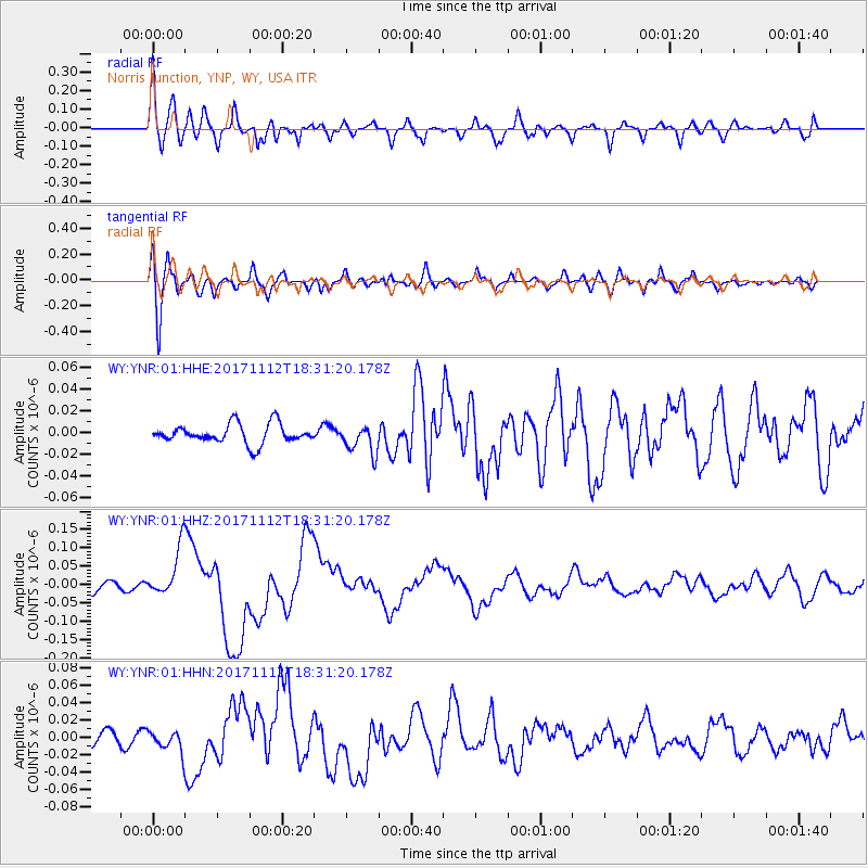
YNR Norris Junction, YNP, WY, USA - Earthquake Result Viewer
*The percent match for this event was below the threshold and hence no stack was calculated.
| Earthquake location: |
Iran-Iraq Border Region |
| Earthquake latitude/longitude: |
34.9/46.0 |
| Earthquake time(UTC): |
2017/11/12 (316) 18:18:17 GMT |
| Earthquake Depth: |
19 km |
| Earthquake Magnitude: |
7.3 Mww |
| Earthquake Catalog/Contributor: |
NEIC PDE/us |
|
| Network: |
WY Yellowstone Wyoming Seismic Network |
| Station: |
YNR Norris Junction, YNP, WY, USA |
| Lat/Lon: |
44.72 N/110.68 W |
| Elevation: |
2336 m |
|
| Distance: |
98.0 deg |
| Az: |
343.411 deg |
| Baz: |
19.215 deg |
| Ray Param: |
$rayparam |
*The percent match for this event was below the threshold and hence was not used in the summary stack. |
|
| Radial Match: |
73.664764 % |
| Radial Bump: |
400 |
| Transverse Match: |
70.184685 % |
| Transverse Bump: |
400 |
| SOD ConfigId: |
2429771 |
| Insert Time: |
2017-11-26 18:23:43.710 +0000 |
| GWidth: |
2.5 |
| Max Bumps: |
400 |
| Tol: |
0.001 |
|
Signal To Noise
| Channel | StoN | STA | LTA |
| WY:YNR:01:HHZ:20171112T18:31:20.178Z | 5.0936623 | 6.730925E-8 | 1.3214313E-8 |
| WY:YNR:01:HHN:20171112T18:31:20.178Z | 1.9897996 | 1.1932553E-8 | 5.9968617E-9 |
| WY:YNR:01:HHE:20171112T18:31:20.178Z | 1.4901726 | 1.3188678E-8 | 8.850436E-9 |
| Arrivals |
| Ps | |
| PpPs | |
| PsPs/PpSs | |


