You are here: Home > Network List > IW - Intermountain West Stations List
> Station MOOW Moose Ponds, Wyoming, USA > Earthquake Result Viewer
MOOW Moose Ponds, Wyoming, USA - Earthquake Result Viewer
*The percent match for this event was below the threshold and hence no stack was calculated.
| Earthquake location: |
Northwest Of Ryukyu Islands |
| Earthquake latitude/longitude: |
27.4/126.7 |
| Earthquake time(UTC): |
2009/03/26 (085) 19:19:59 GMT |
| Earthquake Depth: |
160 km |
| Earthquake Magnitude: |
5.6 MB, 5.9 MW, 5.9 MW |
| Earthquake Catalog/Contributor: |
WHDF/NEIC |
|
| Network: |
IW Intermountain West |
| Station: |
MOOW Moose Ponds, Wyoming, USA |
| Lat/Lon: |
43.75 N/110.74 W |
| Elevation: |
2128 m |
|
| Distance: |
91.8 deg |
| Az: |
37.672 deg |
| Baz: |
311.44 deg |
| Ray Param: |
$rayparam |
*The percent match for this event was below the threshold and hence was not used in the summary stack. |
|
| Radial Match: |
73.0137 % |
| Radial Bump: |
400 |
| Transverse Match: |
67.9071 % |
| Transverse Bump: |
329 |
| SOD ConfigId: |
2658 |
| Insert Time: |
2010-03-09 07:24:33.193 +0000 |
| GWidth: |
2.5 |
| Max Bumps: |
400 |
| Tol: |
0.001 |
|
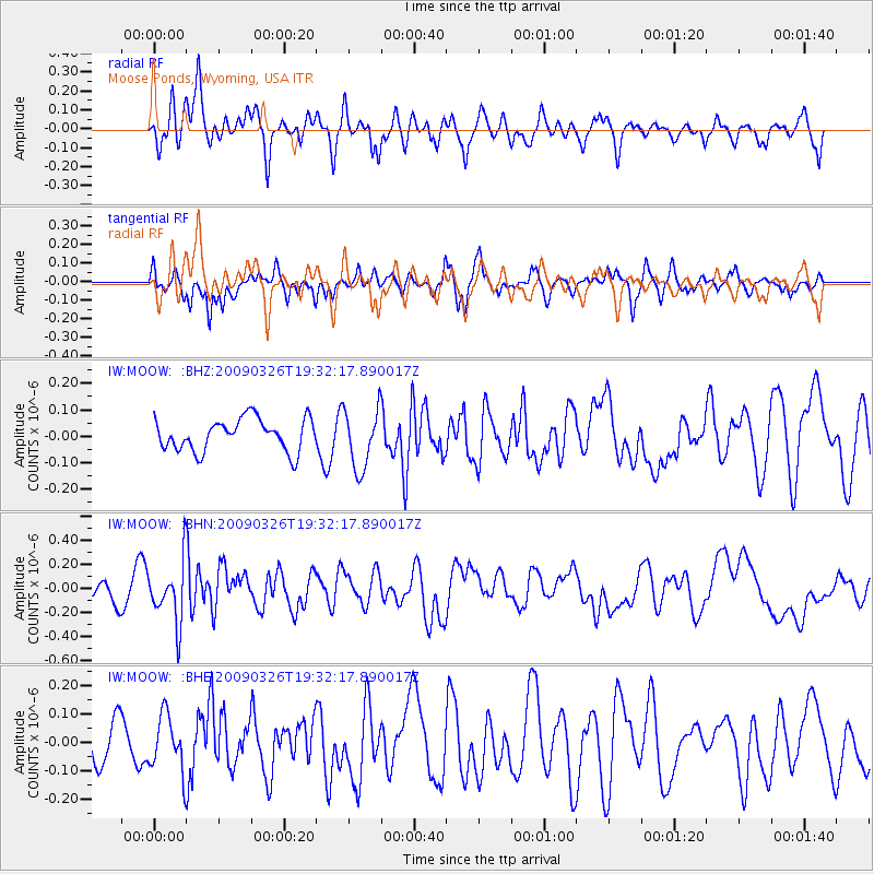
Signal To Noise
| Channel | StoN | STA | LTA |
| IW:MOOW: :BHN:20090326T19:32:17.890017Z | 2.4612455 | 2.49246E-7 | 1.01268235E-7 |
| IW:MOOW: :BHE:20090326T19:32:17.890017Z | 1.3354952 | 9.815833E-8 | 7.349957E-8 |
| IW:MOOW: :BHZ:20090326T19:32:17.890017Z | 1.8876795 | 1.1380524E-7 | 6.0288436E-8 |
| Arrivals |
| Ps | |
| PpPs | |
| PsPs/PpSs | |


