You are here: Home > Network List > IW - Intermountain West Stations List
> Station MOOW Moose Ponds, Wyoming, USA > Earthquake Result Viewer
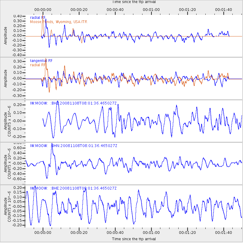
MOOW Moose Ponds, Wyoming, USA - Earthquake Result Viewer
*The percent match for this event was below the threshold and hence no stack was calculated.
| Earthquake location: |
Tonga Islands |
| Earthquake latitude/longitude: |
-15.2/-174.2 |
| Earthquake time(UTC): |
2008/11/08 (313) 07:49:59 GMT |
| Earthquake Depth: |
121 km |
| Earthquake Magnitude: |
6.0 MW, 5.4 MB, 6.0 MW |
| Earthquake Catalog/Contributor: |
WHDF/NEIC |
|
| Network: |
IW Intermountain West |
| Station: |
MOOW Moose Ponds, Wyoming, USA |
| Lat/Lon: |
43.75 N/110.74 W |
| Elevation: |
2128 m |
|
| Distance: |
82.4 deg |
| Az: |
40.863 deg |
| Baz: |
240.635 deg |
| Ray Param: |
$rayparam |
*The percent match for this event was below the threshold and hence was not used in the summary stack. |
|
| Radial Match: |
69.26665 % |
| Radial Bump: |
400 |
| Transverse Match: |
34.78413 % |
| Transverse Bump: |
400 |
| SOD ConfigId: |
2658 |
| Insert Time: |
2010-03-09 07:24:36.253 +0000 |
| GWidth: |
2.5 |
| Max Bumps: |
400 |
| Tol: |
0.001 |
|
Signal To Noise
| Channel | StoN | STA | LTA |
| IW:MOOW: :BHN:20081108T08:01:36.465027Z | 3.897111 | 2.8734672E-7 | 7.373327E-8 |
| IW:MOOW: :BHE:20081108T08:01:36.465027Z | 1.0788575 | 9.87057E-8 | 9.1490946E-8 |
| IW:MOOW: :BHZ:20081108T08:01:36.465027Z | 1.1955967 | 1.1178197E-7 | 9.349472E-8 |
| Arrivals |
| Ps | |
| PpPs | |
| PsPs/PpSs | |


