You are here: Home > Network List > IW - Intermountain West Stations List
> Station MOOW Moose Ponds, Wyoming, USA > Earthquake Result Viewer
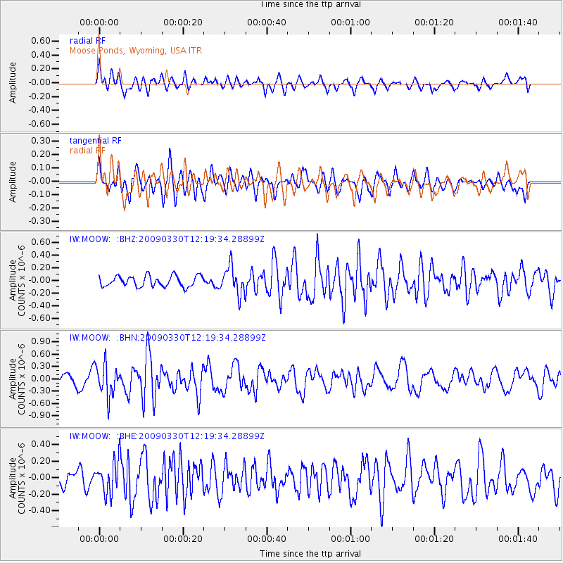
MOOW Moose Ponds, Wyoming, USA - Earthquake Result Viewer
*The percent match for this event was below the threshold and hence no stack was calculated.
| Earthquake location: |
Andreanof Islands, Aleutian Is. |
| Earthquake latitude/longitude: |
51.5/-178.3 |
| Earthquake time(UTC): |
2009/03/30 (089) 12:11:54 GMT |
| Earthquake Depth: |
31 km |
| Earthquake Magnitude: |
6.0 MB, 5.8 MW, 5.7 MW |
| Earthquake Catalog/Contributor: |
WHDF/NEIC |
|
| Network: |
IW Intermountain West |
| Station: |
MOOW Moose Ponds, Wyoming, USA |
| Lat/Lon: |
43.75 N/110.74 W |
| Elevation: |
2128 m |
|
| Distance: |
44.7 deg |
| Az: |
72.268 deg |
| Baz: |
304.806 deg |
| Ray Param: |
$rayparam |
*The percent match for this event was below the threshold and hence was not used in the summary stack. |
|
| Radial Match: |
72.24638 % |
| Radial Bump: |
400 |
| Transverse Match: |
56.19442 % |
| Transverse Bump: |
400 |
| SOD ConfigId: |
2658 |
| Insert Time: |
2010-03-09 07:24:37.265 +0000 |
| GWidth: |
2.5 |
| Max Bumps: |
400 |
| Tol: |
0.001 |
|
Signal To Noise
| Channel | StoN | STA | LTA |
| IW:MOOW: :BHN:20090330T12:19:34.28899Z | 1.5744644 | 3.7794607E-7 | 2.4004737E-7 |
| IW:MOOW: :BHE:20090330T12:19:34.28899Z | 1.4330513 | 1.9385627E-7 | 1.3527516E-7 |
| IW:MOOW: :BHZ:20090330T12:19:34.28899Z | 2.6706684 | 2.2074833E-7 | 8.2656584E-8 |
| Arrivals |
| Ps | |
| PpPs | |
| PsPs/PpSs | |


