You are here: Home > Network List > IW - Intermountain West Stations List
> Station MOOW Moose Ponds, Wyoming, USA > Earthquake Result Viewer
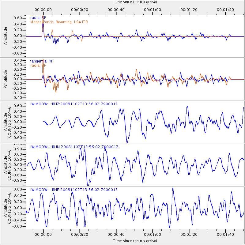
MOOW Moose Ponds, Wyoming, USA - Earthquake Result Viewer
*The percent match for this event was below the threshold and hence no stack was calculated.
| Earthquake location: |
Andreanof Islands, Aleutian Is. |
| Earthquake latitude/longitude: |
51.6/-174.4 |
| Earthquake time(UTC): |
2008/11/02 (307) 13:48:42 GMT |
| Earthquake Depth: |
36 km |
| Earthquake Magnitude: |
5.7 MB, 5.8 MS, 6.1 MW, 6.1 MW |
| Earthquake Catalog/Contributor: |
WHDF/NEIC |
|
| Network: |
IW Intermountain West |
| Station: |
MOOW Moose Ponds, Wyoming, USA |
| Lat/Lon: |
43.75 N/110.74 W |
| Elevation: |
2128 m |
|
| Distance: |
42.3 deg |
| Az: |
74.609 deg |
| Baz: |
303.834 deg |
| Ray Param: |
$rayparam |
*The percent match for this event was below the threshold and hence was not used in the summary stack. |
|
| Radial Match: |
65.342575 % |
| Radial Bump: |
376 |
| Transverse Match: |
61.08094 % |
| Transverse Bump: |
400 |
| SOD ConfigId: |
2658 |
| Insert Time: |
2010-03-09 07:24:39.116 +0000 |
| GWidth: |
2.5 |
| Max Bumps: |
400 |
| Tol: |
0.001 |
|
Signal To Noise
| Channel | StoN | STA | LTA |
| IW:MOOW: :BHN:20081102T13:56:02.790001Z | 2.0352998 | 3.797545E-7 | 1.8658407E-7 |
| IW:MOOW: :BHE:20081102T13:56:02.790001Z | 1.7879924 | 3.3799046E-7 | 1.890335E-7 |
| IW:MOOW: :BHZ:20081102T13:56:02.790001Z | 2.5950782 | 2.9984386E-7 | 1.1554329E-7 |
| Arrivals |
| Ps | |
| PpPs | |
| PsPs/PpSs | |


