You are here: Home > Network List > IW - Intermountain West Stations List
> Station MOOW Moose Ponds, Wyoming, USA > Earthquake Result Viewer
MOOW Moose Ponds, Wyoming, USA - Earthquake Result Viewer
*The percent match for this event was below the threshold and hence no stack was calculated.
| Earthquake location: |
Mendoza Province, Argentina |
| Earthquake latitude/longitude: |
-32.1/-69.7 |
| Earthquake time(UTC): |
2009/05/08 (128) 13:44:53 GMT |
| Earthquake Depth: |
112 km |
| Earthquake Magnitude: |
5.6 MB, 5.4 MW |
| Earthquake Catalog/Contributor: |
WHDF/NEIC |
|
| Network: |
IW Intermountain West |
| Station: |
MOOW Moose Ponds, Wyoming, USA |
| Lat/Lon: |
43.75 N/110.74 W |
| Elevation: |
2128 m |
|
| Distance: |
84.3 deg |
| Az: |
331.414 deg |
| Baz: |
145.901 deg |
| Ray Param: |
$rayparam |
*The percent match for this event was below the threshold and hence was not used in the summary stack. |
|
| Radial Match: |
66.393135 % |
| Radial Bump: |
400 |
| Transverse Match: |
65.29373 % |
| Transverse Bump: |
400 |
| SOD ConfigId: |
2658 |
| Insert Time: |
2010-03-09 07:24:39.965 +0000 |
| GWidth: |
2.5 |
| Max Bumps: |
400 |
| Tol: |
0.001 |
|
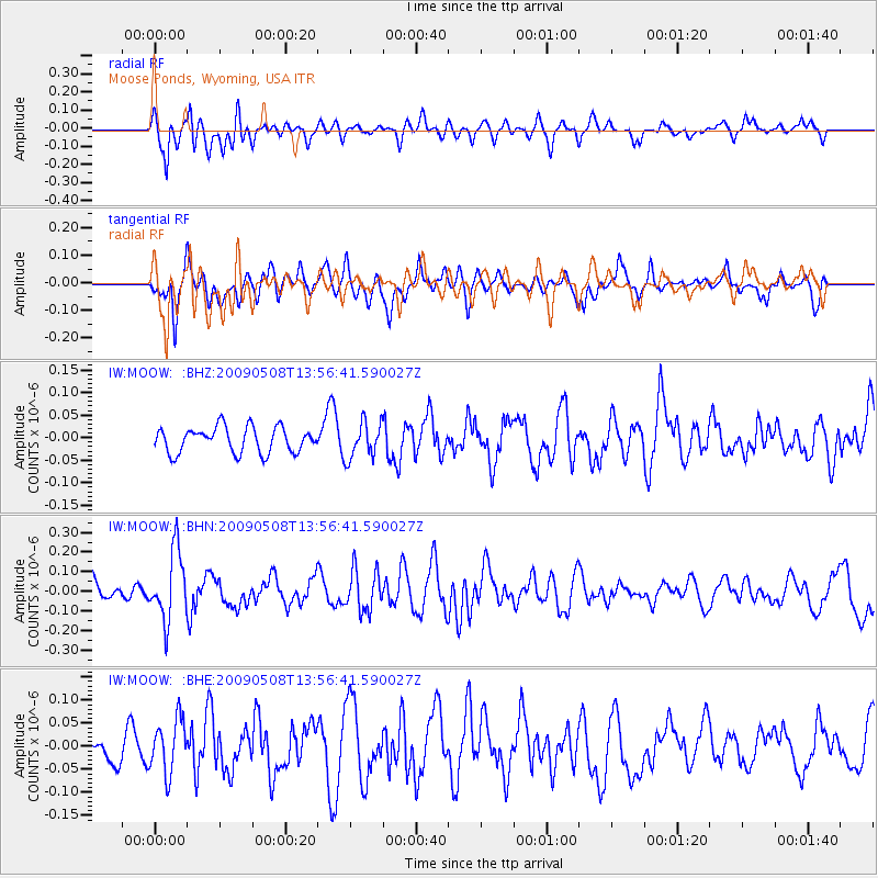
Signal To Noise
| Channel | StoN | STA | LTA |
| IW:MOOW: :BHN:20090508T13:56:41.590027Z | 3.2040193 | 1.7589588E-7 | 5.4898507E-8 |
| IW:MOOW: :BHE:20090508T13:56:41.590027Z | 1.447595 | 5.766844E-8 | 3.9837413E-8 |
| IW:MOOW: :BHZ:20090508T13:56:41.590027Z | 1.423661 | 3.9866524E-8 | 2.8002823E-8 |
| Arrivals |
| Ps | |
| PpPs | |
| PsPs/PpSs | |


