You are here: Home > Network List > IW - Intermountain West Stations List
> Station MOOW Moose Ponds, Wyoming, USA > Earthquake Result Viewer
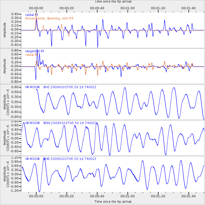
MOOW Moose Ponds, Wyoming, USA - Earthquake Result Viewer
*The percent match for this event was below the threshold and hence no stack was calculated.
| Earthquake location: |
Southern East Pacific Rise |
| Earthquake latitude/longitude: |
-34.8/-107.6 |
| Earthquake time(UTC): |
2009/01/01 (001) 06:27:51 GMT |
| Earthquake Depth: |
10 km |
| Earthquake Magnitude: |
5.8 MW, 5.2 MS, 5.1 MB, 5.8 MW |
| Earthquake Catalog/Contributor: |
WHDF/NEIC |
|
| Network: |
IW Intermountain West |
| Station: |
MOOW Moose Ponds, Wyoming, USA |
| Lat/Lon: |
43.75 N/110.74 W |
| Elevation: |
2128 m |
|
| Distance: |
78.3 deg |
| Az: |
357.708 deg |
| Baz: |
177.398 deg |
| Ray Param: |
$rayparam |
*The percent match for this event was below the threshold and hence was not used in the summary stack. |
|
| Radial Match: |
67.56095 % |
| Radial Bump: |
246 |
| Transverse Match: |
75.4258 % |
| Transverse Bump: |
400 |
| SOD ConfigId: |
2834 |
| Insert Time: |
2010-03-09 07:24:43.908 +0000 |
| GWidth: |
2.5 |
| Max Bumps: |
400 |
| Tol: |
0.001 |
|
Signal To Noise
| Channel | StoN | STA | LTA |
| IW:MOOW: :BHN:20090101T06:39:19.74002Z | 0.8290954 | 3.1584835E-7 | 3.8095536E-7 |
| IW:MOOW: :BHE:20090101T06:39:19.74002Z | 2.566103 | 7.868771E-7 | 3.0664282E-7 |
| IW:MOOW: :BHZ:20090101T06:39:19.74002Z | 0.7262666 | 2.9806625E-7 | 4.1040883E-7 |
| Arrivals |
| Ps | |
| PpPs | |
| PsPs/PpSs | |


