You are here: Home > Network List > IW - Intermountain West Stations List
> Station MOOW Moose Ponds, Wyoming, USA > Earthquake Result Viewer
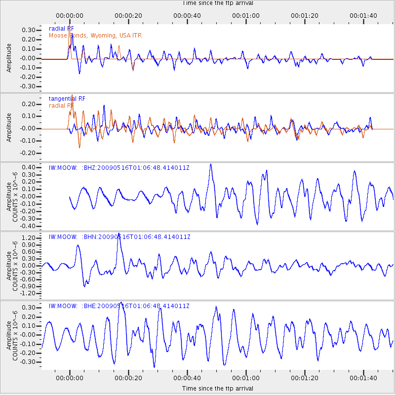
MOOW Moose Ponds, Wyoming, USA - Earthquake Result Viewer
*The percent match for this event was below the threshold and hence no stack was calculated.
| Earthquake location: |
Kermadec Islands Region |
| Earthquake latitude/longitude: |
-31.5/-178.8 |
| Earthquake time(UTC): |
2009/05/16 (136) 00:53:52 GMT |
| Earthquake Depth: |
55 km |
| Earthquake Magnitude: |
6.1 MB, 6.5 MW, 6.3 MW |
| Earthquake Catalog/Contributor: |
WHDF/NEIC |
|
| Network: |
IW Intermountain West |
| Station: |
MOOW Moose Ponds, Wyoming, USA |
| Lat/Lon: |
43.75 N/110.74 W |
| Elevation: |
2128 m |
|
| Distance: |
97.3 deg |
| Az: |
42.66 deg |
| Baz: |
232.995 deg |
| Ray Param: |
$rayparam |
*The percent match for this event was below the threshold and hence was not used in the summary stack. |
|
| Radial Match: |
77.04765 % |
| Radial Bump: |
354 |
| Transverse Match: |
81.86608 % |
| Transverse Bump: |
400 |
| SOD ConfigId: |
2760 |
| Insert Time: |
2010-03-09 07:24:49.233 +0000 |
| GWidth: |
2.5 |
| Max Bumps: |
400 |
| Tol: |
0.001 |
|
Signal To Noise
| Channel | StoN | STA | LTA |
| IW:MOOW: :BHN:20090516T01:06:48.414011Z | 4.983765 | 4.5816296E-7 | 9.1931085E-8 |
| IW:MOOW: :BHE:20090516T01:06:48.414011Z | 0.8376885 | 6.975839E-8 | 8.327486E-8 |
| IW:MOOW: :BHZ:20090516T01:06:48.414011Z | 0.88961864 | 7.174176E-8 | 8.0643275E-8 |
| Arrivals |
| Ps | |
| PpPs | |
| PsPs/PpSs | |


