You are here: Home > Network List > IW - Intermountain West Stations List
> Station MOOW Moose Ponds, Wyoming, USA > Earthquake Result Viewer
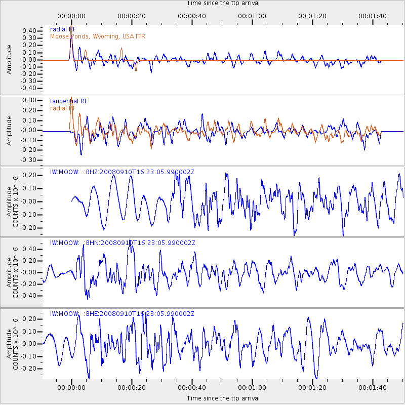
MOOW Moose Ponds, Wyoming, USA - Earthquake Result Viewer
*The percent match for this event was below the threshold and hence no stack was calculated.
| Earthquake location: |
Northern Chile |
| Earthquake latitude/longitude: |
-20.3/-69.2 |
| Earthquake time(UTC): |
2008/09/10 (254) 16:12:04 GMT |
| Earthquake Depth: |
38 km |
| Earthquake Magnitude: |
5.6 MB, 5.3 MS |
| Earthquake Catalog/Contributor: |
WHDF/NEIC |
|
| Network: |
IW Intermountain West |
| Station: |
MOOW Moose Ponds, Wyoming, USA |
| Lat/Lon: |
43.75 N/110.74 W |
| Elevation: |
2128 m |
|
| Distance: |
74.2 deg |
| Az: |
330.05 deg |
| Baz: |
139.7 deg |
| Ray Param: |
$rayparam |
*The percent match for this event was below the threshold and hence was not used in the summary stack. |
|
| Radial Match: |
64.80971 % |
| Radial Bump: |
400 |
| Transverse Match: |
63.943707 % |
| Transverse Bump: |
400 |
| SOD ConfigId: |
2560 |
| Insert Time: |
2010-03-09 07:24:54.566 +0000 |
| GWidth: |
2.5 |
| Max Bumps: |
400 |
| Tol: |
0.001 |
|
Signal To Noise
| Channel | StoN | STA | LTA |
| IW:MOOW: :BHN:20080910T16:23:05.990002Z | 2.1149712 | 2.0550294E-7 | 9.716584E-8 |
| IW:MOOW: :BHE:20080910T16:23:05.990002Z | 1.2201102 | 1.15008326E-7 | 9.426061E-8 |
| IW:MOOW: :BHZ:20080910T16:23:05.990002Z | 0.90565735 | 9.269916E-8 | 1.0235566E-7 |
| Arrivals |
| Ps | |
| PpPs | |
| PsPs/PpSs | |


