You are here: Home > Network List > AK - Alaska Regional Network Stations List
> Station C18K Utukok River, AK, USA > Earthquake Result Viewer
C18K Utukok River, AK, USA - Earthquake Result Viewer
| Earthquake location: |
Southern Iran |
| Earthquake latitude/longitude: |
29.8/50.7 |
| Earthquake time(UTC): |
2021/04/18 (108) 06:41:50 GMT |
| Earthquake Depth: |
10 km |
| Earthquake Magnitude: |
5.8 mww |
| Earthquake Catalog/Contributor: |
NEIC PDE/us |
|
| Network: |
AK Alaska Regional Network |
| Station: |
C18K Utukok River, AK, USA |
| Lat/Lon: |
68.65 N/161.19 W |
| Elevation: |
845 m |
|
| Distance: |
79.1 deg |
| Az: |
11.355 deg |
| Baz: |
332.136 deg |
| Ray Param: |
0.049214453 |
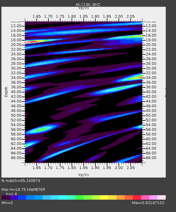
| Estimated Moho Depth: |
18.75 km |
| Estimated Crust Vp/Vs: |
1.60 |
| Assumed Crust Vp: |
5.906 km/s |
| Estimated Crust Vs: |
3.692 km/s |
| Estimated Crust Poisson's Ratio: |
0.18 |
|
| Radial Match: |
85.240974 % |
| Radial Bump: |
400 |
| Transverse Match: |
77.59804 % |
| Transverse Bump: |
400 |
| SOD ConfigId: |
24334971 |
| Insert Time: |
2021-05-02 06:47:14.038 +0000 |
| GWidth: |
2.5 |
| Max Bumps: |
400 |
| Tol: |
0.001 |
|

Signal To Noise
| Channel | StoN | STA | LTA |
| AK:C18K: :BHZ:20210418T06:53:23.21999Z | 12.281488 | 9.4971216E-7 | 7.732876E-8 |
| AK:C18K: :BHN:20210418T06:53:23.21999Z | 2.2055788 | 1.3434699E-7 | 6.0912356E-8 |
| AK:C18K: :BHE:20210418T06:53:23.21999Z | 1.4836086 | 8.501941E-8 | 5.7305822E-8 |
| Arrivals |
| Ps | 2.0 SECOND |
| PpPs | 8.0 SECOND |
| PsPs/PpSs | 10.0 SECOND |


