You are here: Home > Network List > IW - Intermountain West Stations List
> Station PHWY Pilot Hill, Wyoming, USA > Earthquake Result Viewer
PHWY Pilot Hill, Wyoming, USA - Earthquake Result Viewer
| Earthquake location: |
Galapagos Triple Junction Region |
| Earthquake latitude/longitude: |
3.3/-103.8 |
| Earthquake time(UTC): |
2009/10/15 (288) 17:48:21 GMT |
| Earthquake Depth: |
10 km |
| Earthquake Magnitude: |
5.9 MB, 5.7 MS, 6.0 MW, 6.0 MW |
| Earthquake Catalog/Contributor: |
WHDF/NEIC |
|
| Network: |
IW Intermountain West |
| Station: |
PHWY Pilot Hill, Wyoming, USA |
| Lat/Lon: |
41.30 N/105.46 W |
| Elevation: |
2645 m |
|
| Distance: |
37.9 deg |
| Az: |
357.994 deg |
| Baz: |
177.342 deg |
| Ray Param: |
0.07587941 |
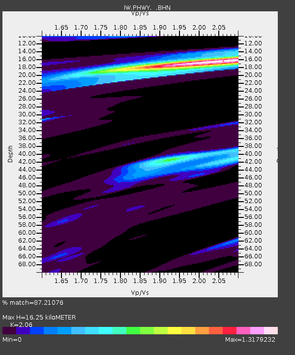
| Estimated Moho Depth: |
16.25 km |
| Estimated Crust Vp/Vs: |
2.06 |
| Assumed Crust Vp: |
6.306 km/s |
| Estimated Crust Vs: |
3.061 km/s |
| Estimated Crust Poisson's Ratio: |
0.35 |
|
| Radial Match: |
87.21076 % |
| Radial Bump: |
322 |
| Transverse Match: |
73.937256 % |
| Transverse Bump: |
400 |
| SOD ConfigId: |
2622 |
| Insert Time: |
2010-03-09 07:25:18.370 +0000 |
| GWidth: |
2.5 |
| Max Bumps: |
400 |
| Tol: |
0.001 |
|

Signal To Noise
| Channel | StoN | STA | LTA |
| IW:PHWY: :BHN:20091015T17:55:08.189011Z | 2.0042138 | 1.219369E-6 | 6.0840273E-7 |
| IW:PHWY: :BHE:20091015T17:55:08.189011Z | 1.2882491 | 6.0383127E-7 | 4.6872242E-7 |
| IW:PHWY: :BHZ:20091015T17:55:08.189011Z | 0.92275757 | 5.679486E-7 | 6.154906E-7 |
| Arrivals |
| Ps | 2.9 SECOND |
| PpPs | 7.4 SECOND |
| PsPs/PpSs | 10 SECOND |


