You are here: Home > Network List > AV - Alaska Volcano Observatory Stations List
> Station SPCR Ckakachatna River, Mount Spurr, Alaska > Earthquake Result Viewer
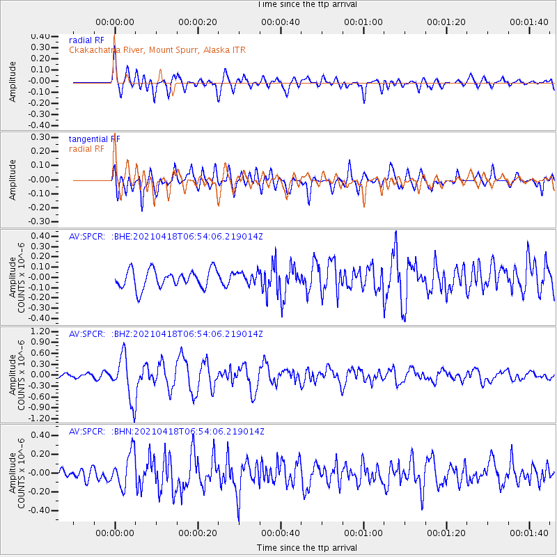
SPCR Ckakachatna River, Mount Spurr, Alaska - Earthquake Result Viewer
*The percent match for this event was below the threshold and hence no stack was calculated.
| Earthquake location: |
Southern Iran |
| Earthquake latitude/longitude: |
29.8/50.7 |
| Earthquake time(UTC): |
2021/04/18 (108) 06:41:50 GMT |
| Earthquake Depth: |
10 km |
| Earthquake Magnitude: |
5.8 mww |
| Earthquake Catalog/Contributor: |
NEIC PDE/us |
|
| Network: |
AV Alaska Volcano Observatory |
| Station: |
SPCR Ckakachatna River, Mount Spurr, Alaska |
| Lat/Lon: |
61.20 N/152.21 W |
| Elevation: |
984 m |
|
| Distance: |
87.4 deg |
| Az: |
10.862 deg |
| Baz: |
340.226 deg |
| Ray Param: |
$rayparam |
*The percent match for this event was below the threshold and hence was not used in the summary stack. |
|
| Radial Match: |
73.36742 % |
| Radial Bump: |
400 |
| Transverse Match: |
71.91421 % |
| Transverse Bump: |
400 |
| SOD ConfigId: |
24334971 |
| Insert Time: |
2021-05-02 06:48:55.419 +0000 |
| GWidth: |
2.5 |
| Max Bumps: |
400 |
| Tol: |
0.001 |
|
Signal To Noise
| Channel | StoN | STA | LTA |
| AV:SPCR: :BHZ:20210418T06:54:06.219014Z | 7.5898576 | 6.3281954E-7 | 8.3377E-8 |
| AV:SPCR: :BHN:20210418T06:54:06.219014Z | 3.123252 | 1.8958117E-7 | 6.0699925E-8 |
| AV:SPCR: :BHE:20210418T06:54:06.219014Z | 0.62009746 | 5.503349E-8 | 8.874974E-8 |
| Arrivals |
| Ps | |
| PpPs | |
| PsPs/PpSs | |


