You are here: Home > Network List > IW - Intermountain West Stations List
> Station PHWY Pilot Hill, Wyoming, USA > Earthquake Result Viewer
PHWY Pilot Hill, Wyoming, USA - Earthquake Result Viewer
| Earthquake location: |
Northern Mid-Atlantic Ridge |
| Earthquake latitude/longitude: |
23.9/-46.1 |
| Earthquake time(UTC): |
2009/06/06 (157) 20:33:28 GMT |
| Earthquake Depth: |
14 km |
| Earthquake Magnitude: |
6.0 MB, 5.7 MS, 6.0 MW, 6.0 MW |
| Earthquake Catalog/Contributor: |
WHDF/NEIC |
|
| Network: |
IW Intermountain West |
| Station: |
PHWY Pilot Hill, Wyoming, USA |
| Lat/Lon: |
41.30 N/105.46 W |
| Elevation: |
2645 m |
|
| Distance: |
52.0 deg |
| Az: |
304.617 deg |
| Baz: |
90.272 deg |
| Ray Param: |
0.06705566 |
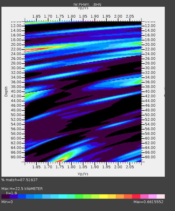
| Estimated Moho Depth: |
22.5 km |
| Estimated Crust Vp/Vs: |
1.60 |
| Assumed Crust Vp: |
6.306 km/s |
| Estimated Crust Vs: |
3.941 km/s |
| Estimated Crust Poisson's Ratio: |
0.18 |
|
| Radial Match: |
87.51637 % |
| Radial Bump: |
400 |
| Transverse Match: |
63.548565 % |
| Transverse Bump: |
400 |
| SOD ConfigId: |
2648 |
| Insert Time: |
2010-03-09 07:25:25.434 +0000 |
| GWidth: |
2.5 |
| Max Bumps: |
400 |
| Tol: |
0.001 |
|

Signal To Noise
| Channel | StoN | STA | LTA |
| IW:PHWY: :BHN:20090606T20:42:06.34001Z | 5.466366 | 3.7243345E-7 | 6.813182E-8 |
| IW:PHWY: :BHE:20090606T20:42:06.34001Z | 0.64340067 | 8.612579E-8 | 1.3386027E-7 |
| IW:PHWY: :BHZ:20090606T20:42:06.34001Z | 2.389511 | 2.4673173E-7 | 1.03256156E-7 |
| Arrivals |
| Ps | 2.3 SECOND |
| PpPs | 8.7 SECOND |
| PsPs/PpSs | 11 SECOND |


