You are here: Home > Network List > TA - USArray Transportable Network (new EarthScope stations) Stations List
> Station F26K Sheenjek River, AK, USA > Earthquake Result Viewer
F26K Sheenjek River, AK, USA - Earthquake Result Viewer

| Earthquake location: |
Southern Iran |
| Earthquake latitude/longitude: |
29.8/50.7 |
| Earthquake time(UTC): |
2021/04/18 (108) 06:41:50 GMT |
| Earthquake Depth: |
10 km |
| Earthquake Magnitude: |
5.8 mww |
| Earthquake Catalog/Contributor: |
NEIC PDE/us |
|
| Network: |
TA USArray Transportable Network (new EarthScope stations) |
| Station: |
F26K Sheenjek River, AK, USA |
| Lat/Lon: |
67.69 N/144.15 W |
| Elevation: |
683 m |
|
| Distance: |
82.2 deg |
| Az: |
5.654 deg |
| Baz: |
347.035 deg |
| Ray Param: |
0.04706881 |
| Estimated Moho Depth: |
14.5 km |
| Estimated Crust Vp/Vs: |
2.06 |
| Assumed Crust Vp: |
6.522 km/s |
| Estimated Crust Vs: |
3.17 km/s |
| Estimated Crust Poisson's Ratio: |
0.35 |
|
| Radial Match: |
85.57514 % |
| Radial Bump: |
393 |
| Transverse Match: |
67.98506 % |
| Transverse Bump: |
400 |
| SOD ConfigId: |
24334971 |
| Insert Time: |
2021-05-02 06:56:41.320 +0000 |
| GWidth: |
2.5 |
| Max Bumps: |
400 |
| Tol: |
0.001 |
|
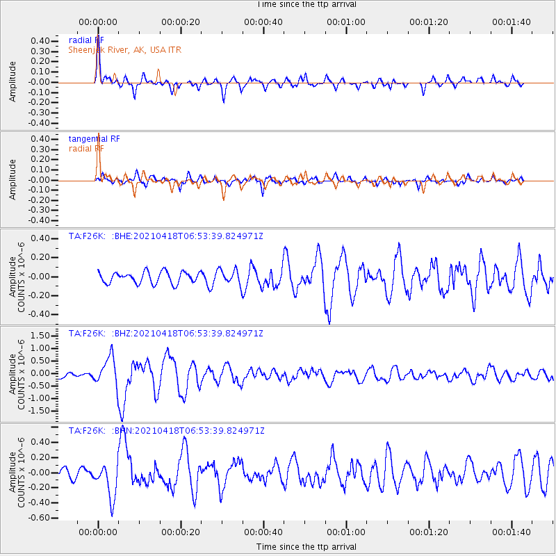
Signal To Noise
| Channel | StoN | STA | LTA |
| TA:F26K: :BHZ:20210418T06:53:39.824971Z | 7.3135095 | 5.877536E-7 | 8.036547E-8 |
| TA:F26K: :BHN:20210418T06:53:39.824971Z | 2.8851228 | 2.377935E-7 | 8.2420584E-8 |
| TA:F26K: :BHE:20210418T06:53:39.824971Z | 1.3234316 | 7.933784E-8 | 5.9948576E-8 |
| Arrivals |
| Ps | 2.4 SECOND |
| PpPs | 6.6 SECOND |
| PsPs/PpSs | 9.0 SECOND |


