You are here: Home > Network List > TA - USArray Transportable Network (new EarthScope stations) Stations List
> Station G16K Koyuk River, AK, USA > Earthquake Result Viewer
G16K Koyuk River, AK, USA - Earthquake Result Viewer

| Earthquake location: |
Southern Iran |
| Earthquake latitude/longitude: |
29.8/50.7 |
| Earthquake time(UTC): |
2021/04/18 (108) 06:41:50 GMT |
| Earthquake Depth: |
10 km |
| Earthquake Magnitude: |
5.8 mww |
| Earthquake Catalog/Contributor: |
NEIC PDE/us |
|
| Network: |
TA USArray Transportable Network (new EarthScope stations) |
| Station: |
G16K Koyuk River, AK, USA |
| Lat/Lon: |
65.39 N/162.35 W |
| Elevation: |
169 m |
|
| Distance: |
81.7 deg |
| Az: |
13.331 deg |
| Baz: |
331.397 deg |
| Ray Param: |
0.04738046 |
| Estimated Moho Depth: |
32.75 km |
| Estimated Crust Vp/Vs: |
1.70 |
| Assumed Crust Vp: |
6.276 km/s |
| Estimated Crust Vs: |
3.697 km/s |
| Estimated Crust Poisson's Ratio: |
0.23 |
|
| Radial Match: |
84.553734 % |
| Radial Bump: |
400 |
| Transverse Match: |
67.71776 % |
| Transverse Bump: |
400 |
| SOD ConfigId: |
24334971 |
| Insert Time: |
2021-05-02 06:56:48.149 +0000 |
| GWidth: |
2.5 |
| Max Bumps: |
400 |
| Tol: |
0.001 |
|
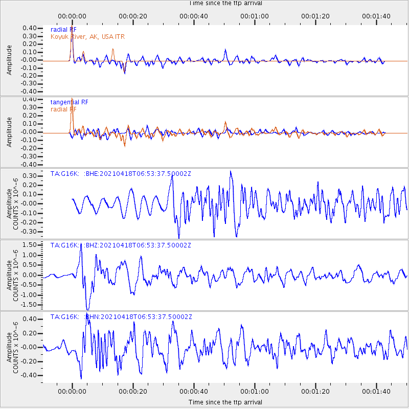
Signal To Noise
| Channel | StoN | STA | LTA |
| TA:G16K: :BHZ:20210418T06:53:37.50002Z | 11.464237 | 7.0489864E-7 | 6.1486745E-8 |
| TA:G16K: :BHN:20210418T06:53:37.50002Z | 3.8565505 | 2.0236378E-7 | 5.247274E-8 |
| TA:G16K: :BHE:20210418T06:53:37.50002Z | 1.9988936 | 1.5026639E-7 | 7.517478E-8 |
| Arrivals |
| Ps | 3.7 SECOND |
| PpPs | 14 SECOND |
| PsPs/PpSs | 17 SECOND |


