You are here: Home > Network List > TA - USArray Transportable Network (new EarthScope stations) Stations List
> Station G18K Tagagawik, AK, USA > Earthquake Result Viewer
G18K Tagagawik, AK, USA - Earthquake Result Viewer
| Earthquake location: |
Southern Iran |
| Earthquake latitude/longitude: |
29.8/50.7 |
| Earthquake time(UTC): |
2021/04/18 (108) 06:41:50 GMT |
| Earthquake Depth: |
10 km |
| Earthquake Magnitude: |
5.8 mww |
| Earthquake Catalog/Contributor: |
NEIC PDE/us |
|
| Network: |
TA USArray Transportable Network (new EarthScope stations) |
| Station: |
G18K Tagagawik, AK, USA |
| Lat/Lon: |
65.89 N/158.65 W |
| Elevation: |
484 m |
|
| Distance: |
82.0 deg |
| Az: |
11.719 deg |
| Baz: |
334.537 deg |
| Ray Param: |
0.047201965 |
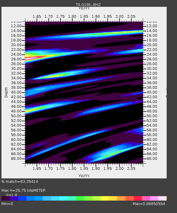
| Estimated Moho Depth: |
25.75 km |
| Estimated Crust Vp/Vs: |
1.60 |
| Assumed Crust Vp: |
6.1 km/s |
| Estimated Crust Vs: |
3.812 km/s |
| Estimated Crust Poisson's Ratio: |
0.18 |
|
| Radial Match: |
83.35414 % |
| Radial Bump: |
400 |
| Transverse Match: |
66.02315 % |
| Transverse Bump: |
400 |
| SOD ConfigId: |
24334971 |
| Insert Time: |
2021-05-02 06:56:49.727 +0000 |
| GWidth: |
2.5 |
| Max Bumps: |
400 |
| Tol: |
0.001 |
|

Signal To Noise
| Channel | StoN | STA | LTA |
| TA:G18K: :BHZ:20210418T06:53:38.800007Z | 7.560684 | 7.2495925E-7 | 9.5885405E-8 |
| TA:G18K: :BHN:20210418T06:53:38.800007Z | 4.144878 | 2.2107221E-7 | 5.3336247E-8 |
| TA:G18K: :BHE:20210418T06:53:38.800007Z | 2.3796134 | 1.4448615E-7 | 6.071833E-8 |
| Arrivals |
| Ps | 2.6 SECOND |
| PpPs | 11 SECOND |
| PsPs/PpSs | 13 SECOND |


