You are here: Home > Network List > TA - USArray Transportable Network (new EarthScope stations) Stations List
> Station G21K Allakaket, AK, USA > Earthquake Result Viewer
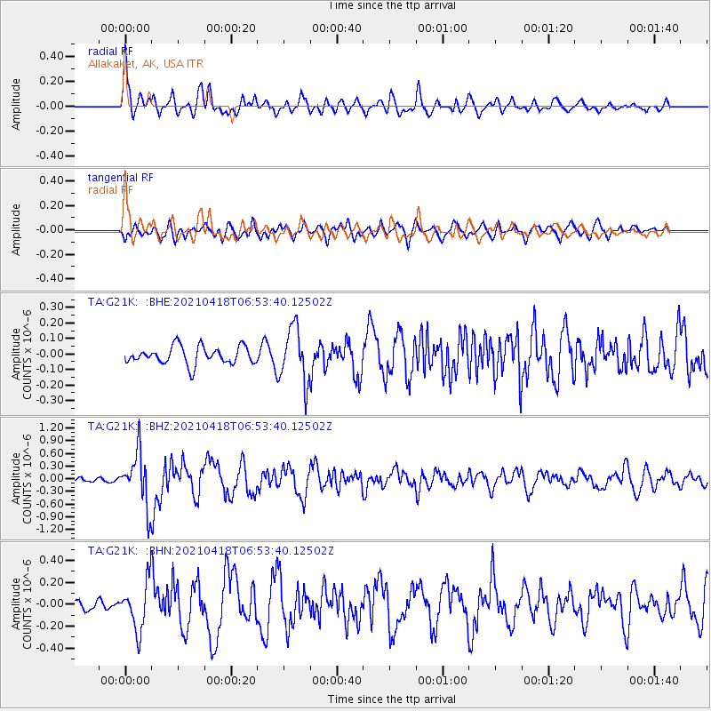
G21K Allakaket, AK, USA - Earthquake Result Viewer
*The percent match for this event was below the threshold and hence no stack was calculated.
| Earthquake location: |
Southern Iran |
| Earthquake latitude/longitude: |
29.8/50.7 |
| Earthquake time(UTC): |
2021/04/18 (108) 06:41:50 GMT |
| Earthquake Depth: |
10 km |
| Earthquake Magnitude: |
5.8 mww |
| Earthquake Catalog/Contributor: |
NEIC PDE/us |
|
| Network: |
TA USArray Transportable Network (new EarthScope stations) |
| Station: |
G21K Allakaket, AK, USA |
| Lat/Lon: |
66.52 N/153.51 W |
| Elevation: |
446 m |
|
| Distance: |
82.2 deg |
| Az: |
9.534 deg |
| Baz: |
338.943 deg |
| Ray Param: |
$rayparam |
*The percent match for this event was below the threshold and hence was not used in the summary stack. |
|
| Radial Match: |
78.36741 % |
| Radial Bump: |
400 |
| Transverse Match: |
69.44663 % |
| Transverse Bump: |
400 |
| SOD ConfigId: |
24334971 |
| Insert Time: |
2021-05-02 06:56:50.968 +0000 |
| GWidth: |
2.5 |
| Max Bumps: |
400 |
| Tol: |
0.001 |
|
Signal To Noise
| Channel | StoN | STA | LTA |
| TA:G21K: :BHZ:20210418T06:53:40.12502Z | 7.2373624 | 6.3774496E-7 | 8.811842E-8 |
| TA:G21K: :BHN:20210418T06:53:40.12502Z | 2.8441684 | 2.2214671E-7 | 7.810603E-8 |
| TA:G21K: :BHE:20210418T06:53:40.12502Z | 3.0873296 | 1.7513764E-7 | 5.6727874E-8 |
| Arrivals |
| Ps | |
| PpPs | |
| PsPs/PpSs | |


