You are here: Home > Network List > TA - USArray Transportable Network (new EarthScope stations) Stations List
> Station H19K Roundabout Mountain, AK, USA > Earthquake Result Viewer
H19K Roundabout Mountain, AK, USA - Earthquake Result Viewer
| Earthquake location: |
Southern Iran |
| Earthquake latitude/longitude: |
29.8/50.7 |
| Earthquake time(UTC): |
2021/04/18 (108) 06:41:50 GMT |
| Earthquake Depth: |
10 km |
| Earthquake Magnitude: |
5.8 mww |
| Earthquake Catalog/Contributor: |
NEIC PDE/us |
|
| Network: |
TA USArray Transportable Network (new EarthScope stations) |
| Station: |
H19K Roundabout Mountain, AK, USA |
| Lat/Lon: |
65.53 N/156.45 W |
| Elevation: |
107 m |
|
| Distance: |
82.7 deg |
| Az: |
11.037 deg |
| Baz: |
336.453 deg |
| Ray Param: |
0.04670965 |
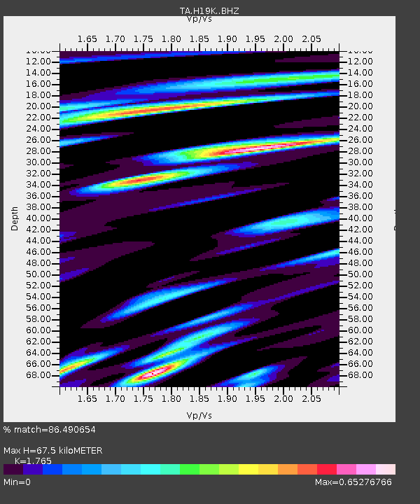
| Estimated Moho Depth: |
67.5 km |
| Estimated Crust Vp/Vs: |
1.76 |
| Assumed Crust Vp: |
6.182 km/s |
| Estimated Crust Vs: |
3.503 km/s |
| Estimated Crust Poisson's Ratio: |
0.26 |
|
| Radial Match: |
86.490654 % |
| Radial Bump: |
400 |
| Transverse Match: |
64.72784 % |
| Transverse Bump: |
400 |
| SOD ConfigId: |
24334971 |
| Insert Time: |
2021-05-02 06:57:01.509 +0000 |
| GWidth: |
2.5 |
| Max Bumps: |
400 |
| Tol: |
0.001 |
|

Signal To Noise
| Channel | StoN | STA | LTA |
| TA:H19K: :BHZ:20210418T06:53:42.524983Z | 7.8495007 | 8.4080267E-7 | 1.0711543E-7 |
| TA:H19K: :BHN:20210418T06:53:42.524983Z | 3.6996956 | 2.6468055E-7 | 7.154117E-8 |
| TA:H19K: :BHE:20210418T06:53:42.524983Z | 1.7453955 | 1.2948786E-7 | 7.418826E-8 |
| Arrivals |
| Ps | 8.6 SECOND |
| PpPs | 29 SECOND |
| PsPs/PpSs | 38 SECOND |


