You are here: Home > Network List > TA - USArray Transportable Network (new EarthScope stations) Stations List
> Station J16K Anvik River, AK, USA > Earthquake Result Viewer
J16K Anvik River, AK, USA - Earthquake Result Viewer
| Earthquake location: |
Southern Iran |
| Earthquake latitude/longitude: |
29.8/50.7 |
| Earthquake time(UTC): |
2021/04/18 (108) 06:41:50 GMT |
| Earthquake Depth: |
10 km |
| Earthquake Magnitude: |
5.8 mww |
| Earthquake Catalog/Contributor: |
NEIC PDE/us |
|
| Network: |
TA USArray Transportable Network (new EarthScope stations) |
| Station: |
J16K Anvik River, AK, USA |
| Lat/Lon: |
63.28 N/160.60 W |
| Elevation: |
328 m |
|
| Distance: |
84.0 deg |
| Az: |
13.646 deg |
| Baz: |
333.015 deg |
| Ray Param: |
0.045810867 |
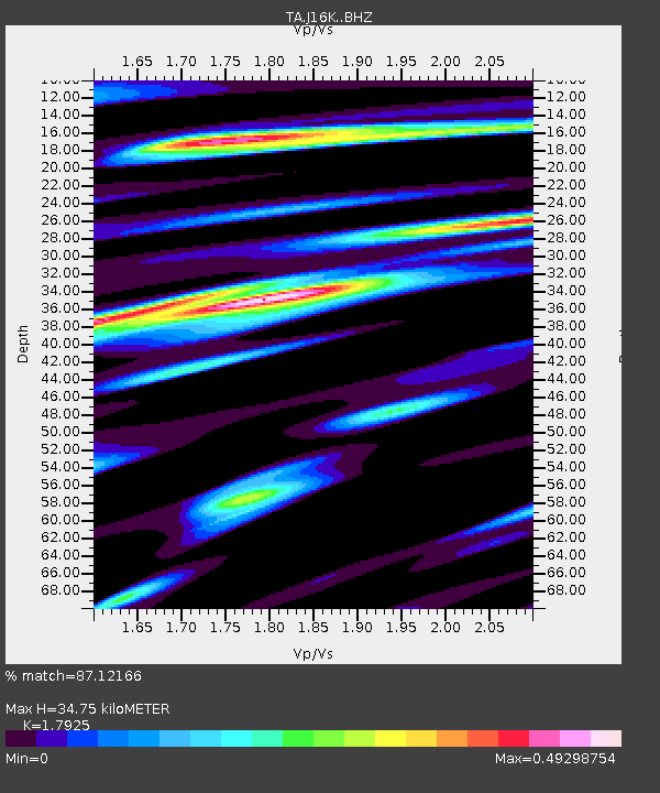
| Estimated Moho Depth: |
34.75 km |
| Estimated Crust Vp/Vs: |
1.79 |
| Assumed Crust Vp: |
6.276 km/s |
| Estimated Crust Vs: |
3.501 km/s |
| Estimated Crust Poisson's Ratio: |
0.27 |
|
| Radial Match: |
87.12166 % |
| Radial Bump: |
400 |
| Transverse Match: |
66.159904 % |
| Transverse Bump: |
400 |
| SOD ConfigId: |
24334971 |
| Insert Time: |
2021-05-02 06:57:15.864 +0000 |
| GWidth: |
2.5 |
| Max Bumps: |
400 |
| Tol: |
0.001 |
|

Signal To Noise
| Channel | StoN | STA | LTA |
| TA:J16K: :BHZ:20210418T06:53:49.024983Z | 6.0166135 | 8.329587E-7 | 1.384431E-7 |
| TA:J16K: :BHN:20210418T06:53:49.024983Z | 3.7515073 | 2.8899998E-7 | 7.70357E-8 |
| TA:J16K: :BHE:20210418T06:53:49.024983Z | 1.8737577 | 1.3197464E-7 | 7.0433146E-8 |
| Arrivals |
| Ps | 4.5 SECOND |
| PpPs | 15 SECOND |
| PsPs/PpSs | 20 SECOND |


