You are here: Home > Network List > TA - USArray Transportable Network (new EarthScope stations) Stations List
> Station M22K Willow, AK, USA > Earthquake Result Viewer
M22K Willow, AK, USA - Earthquake Result Viewer
| Earthquake location: |
Southern Iran |
| Earthquake latitude/longitude: |
29.8/50.7 |
| Earthquake time(UTC): |
2021/04/18 (108) 06:41:50 GMT |
| Earthquake Depth: |
10 km |
| Earthquake Magnitude: |
5.8 mww |
| Earthquake Catalog/Contributor: |
NEIC PDE/us |
|
| Network: |
TA USArray Transportable Network (new EarthScope stations) |
| Station: |
M22K Willow, AK, USA |
| Lat/Lon: |
61.75 N/150.12 W |
| Elevation: |
57 m |
|
| Distance: |
87.2 deg |
| Az: |
9.733 deg |
| Baz: |
342.006 deg |
| Ray Param: |
0.043464974 |
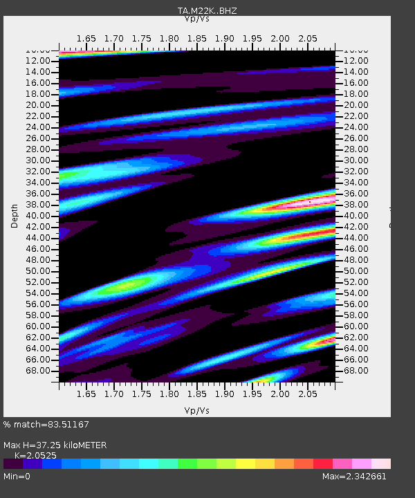
| Estimated Moho Depth: |
37.25 km |
| Estimated Crust Vp/Vs: |
2.05 |
| Assumed Crust Vp: |
6.302 km/s |
| Estimated Crust Vs: |
3.07 km/s |
| Estimated Crust Poisson's Ratio: |
0.34 |
|
| Radial Match: |
83.51167 % |
| Radial Bump: |
400 |
| Transverse Match: |
77.72903 % |
| Transverse Bump: |
400 |
| SOD ConfigId: |
24334971 |
| Insert Time: |
2021-05-02 06:57:34.798 +0000 |
| GWidth: |
2.5 |
| Max Bumps: |
400 |
| Tol: |
0.001 |
|

Signal To Noise
| Channel | StoN | STA | LTA |
| TA:M22K: :BHZ:20210418T06:54:05.25002Z | 14.5736685 | 1.2262894E-6 | 8.414418E-8 |
| TA:M22K: :BHN:20210418T06:54:05.25002Z | 4.757923 | 5.262511E-7 | 1.10605214E-7 |
| TA:M22K: :BHE:20210418T06:54:05.25002Z | 1.5482605 | 2.2040774E-7 | 1.4235832E-7 |
| Arrivals |
| Ps | 6.3 SECOND |
| PpPs | 18 SECOND |
| PsPs/PpSs | 24 SECOND |


