You are here: Home > Network List > II - Global Seismograph Network (GSN - IRIS/IDA) Stations List
> Station WRAB Tennant Creek, NT, Australia > Earthquake Result Viewer
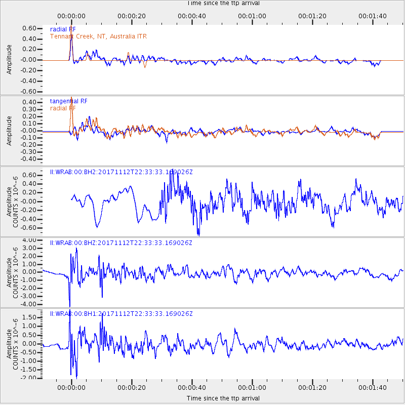
WRAB Tennant Creek, NT, Australia - Earthquake Result Viewer
*The percent match for this event was below the threshold and hence no stack was calculated.
| Earthquake location: |
Off East Coast Of Honshu, Japan |
| Earthquake latitude/longitude: |
38.1/144.9 |
| Earthquake time(UTC): |
2017/11/12 (316) 22:24:07 GMT |
| Earthquake Depth: |
9.5 km |
| Earthquake Magnitude: |
5.8 Mww |
| Earthquake Catalog/Contributor: |
NEIC PDE/us |
|
| Network: |
II Global Seismograph Network (GSN - IRIS/IDA) |
| Station: |
WRAB Tennant Creek, NT, Australia |
| Lat/Lon: |
19.93 S/134.36 E |
| Elevation: |
366 m |
|
| Distance: |
58.5 deg |
| Az: |
191.63 deg |
| Baz: |
9.739 deg |
| Ray Param: |
$rayparam |
*The percent match for this event was below the threshold and hence was not used in the summary stack. |
|
| Radial Match: |
66.308556 % |
| Radial Bump: |
400 |
| Transverse Match: |
74.25872 % |
| Transverse Bump: |
360 |
| SOD ConfigId: |
2429771 |
| Insert Time: |
2017-11-26 22:26:29.644 +0000 |
| GWidth: |
2.5 |
| Max Bumps: |
400 |
| Tol: |
0.001 |
|
Signal To Noise
| Channel | StoN | STA | LTA |
| II:WRAB:00:BHZ:20171112T22:33:33.169026Z | 4.8261433 | 1.5856341E-6 | 3.2855098E-7 |
| II:WRAB:00:BH1:20171112T22:33:33.169026Z | 8.968777 | 9.0535855E-7 | 1.0094559E-7 |
| II:WRAB:00:BH2:20171112T22:33:33.169026Z | 1.5160537 | 3.4675642E-7 | 2.2872305E-7 |
| Arrivals |
| Ps | |
| PpPs | |
| PsPs/PpSs | |


