You are here: Home > Network List > IU - Global Seismograph Network (GSN - IRIS/USGS) Stations List
> Station CTAO Charters Towers, Australia > Earthquake Result Viewer
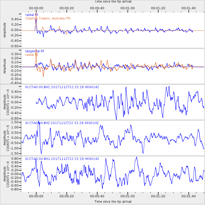
CTAO Charters Towers, Australia - Earthquake Result Viewer
*The percent match for this event was below the threshold and hence no stack was calculated.
| Earthquake location: |
Off East Coast Of Honshu, Japan |
| Earthquake latitude/longitude: |
38.1/144.9 |
| Earthquake time(UTC): |
2017/11/12 (316) 22:24:07 GMT |
| Earthquake Depth: |
9.5 km |
| Earthquake Magnitude: |
5.8 Mww |
| Earthquake Catalog/Contributor: |
NEIC PDE/us |
|
| Network: |
IU Global Seismograph Network (GSN - IRIS/USGS) |
| Station: |
CTAO Charters Towers, Australia |
| Lat/Lon: |
20.09 S/146.25 E |
| Elevation: |
357 m |
|
| Distance: |
57.8 deg |
| Az: |
178.485 deg |
| Baz: |
358.727 deg |
| Ray Param: |
$rayparam |
*The percent match for this event was below the threshold and hence was not used in the summary stack. |
|
| Radial Match: |
79.03049 % |
| Radial Bump: |
380 |
| Transverse Match: |
68.87581 % |
| Transverse Bump: |
400 |
| SOD ConfigId: |
2429771 |
| Insert Time: |
2017-11-26 22:26:39.213 +0000 |
| GWidth: |
2.5 |
| Max Bumps: |
400 |
| Tol: |
0.001 |
|
Signal To Noise
| Channel | StoN | STA | LTA |
| IU:CTAO:00:BHZ:20171112T22:33:28.469014Z | 4.5277066 | 9.4270024E-7 | 2.08207E-7 |
| IU:CTAO:00:BH1:20171112T22:33:28.469014Z | 2.4078414 | 4.3672344E-7 | 1.813755E-7 |
| IU:CTAO:00:BH2:20171112T22:33:28.469014Z | 1.1656704 | 1.430985E-7 | 1.227607E-7 |
| Arrivals |
| Ps | |
| PpPs | |
| PsPs/PpSs | |


