You are here: Home > Network List > IU - Global Seismograph Network (GSN - IRIS/USGS) Stations List
> Station FURI Mt. Furi, Ethiopia > Earthquake Result Viewer
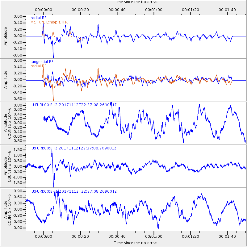
FURI Mt. Furi, Ethiopia - Earthquake Result Viewer
*The percent match for this event was below the threshold and hence no stack was calculated.
| Earthquake location: |
Off East Coast Of Honshu, Japan |
| Earthquake latitude/longitude: |
38.1/144.9 |
| Earthquake time(UTC): |
2017/11/12 (316) 22:24:07 GMT |
| Earthquake Depth: |
9.5 km |
| Earthquake Magnitude: |
5.8 Mww |
| Earthquake Catalog/Contributor: |
NEIC PDE/us |
|
| Network: |
IU Global Seismograph Network (GSN - IRIS/USGS) |
| Station: |
FURI Mt. Furi, Ethiopia |
| Lat/Lon: |
8.90 N/38.68 E |
| Elevation: |
2570 m |
|
| Distance: |
97.1 deg |
| Az: |
287.028 deg |
| Baz: |
49.807 deg |
| Ray Param: |
$rayparam |
*The percent match for this event was below the threshold and hence was not used in the summary stack. |
|
| Radial Match: |
74.53464 % |
| Radial Bump: |
344 |
| Transverse Match: |
83.709404 % |
| Transverse Bump: |
390 |
| SOD ConfigId: |
2429771 |
| Insert Time: |
2017-11-26 22:26:42.726 +0000 |
| GWidth: |
2.5 |
| Max Bumps: |
400 |
| Tol: |
0.001 |
|
Signal To Noise
| Channel | StoN | STA | LTA |
| IU:FURI:00:BHZ:20171112T22:37:08.269001Z | 3.1398869 | 4.970868E-7 | 1.5831358E-7 |
| IU:FURI:00:BH1:20171112T22:37:08.269001Z | 1.4221195 | 4.409252E-7 | 3.100479E-7 |
| IU:FURI:00:BH2:20171112T22:37:08.269001Z | 1.186412 | 3.4518538E-7 | 2.90949E-7 |
| Arrivals |
| Ps | |
| PpPs | |
| PsPs/PpSs | |


