You are here: Home > Network List > IW - Intermountain West Stations List
> Station PLID Pearl Lake, Idaho, USA > Earthquake Result Viewer
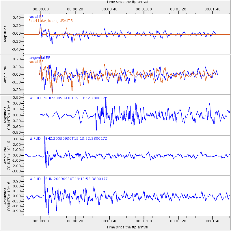
PLID Pearl Lake, Idaho, USA - Earthquake Result Viewer
*The percent match for this event was below the threshold and hence no stack was calculated.
| Earthquake location: |
Peru-Bolivia Border Region |
| Earthquake latitude/longitude: |
-15.6/-69.3 |
| Earthquake time(UTC): |
2009/09/30 (273) 19:03:17 GMT |
| Earthquake Depth: |
255 km |
| Earthquake Magnitude: |
5.9 MB, 5.8 MW |
| Earthquake Catalog/Contributor: |
WHDF/NEIC |
|
| Network: |
IW Intermountain West |
| Station: |
PLID Pearl Lake, Idaho, USA |
| Lat/Lon: |
45.09 N/116.00 W |
| Elevation: |
2164 m |
|
| Distance: |
73.7 deg |
| Az: |
327.512 deg |
| Baz: |
133.045 deg |
| Ray Param: |
$rayparam |
*The percent match for this event was below the threshold and hence was not used in the summary stack. |
|
| Radial Match: |
57.049084 % |
| Radial Bump: |
395 |
| Transverse Match: |
72.87251 % |
| Transverse Bump: |
354 |
| SOD ConfigId: |
2622 |
| Insert Time: |
2010-03-09 07:27:21.025 +0000 |
| GWidth: |
2.5 |
| Max Bumps: |
400 |
| Tol: |
0.001 |
|
Signal To Noise
| Channel | StoN | STA | LTA |
| IW:PLID: :BHZ:20090930T19:13:52.380017Z | 9.826089 | 1.1625904E-6 | 1.183167E-7 |
| IW:PLID: :BHN:20090930T19:13:52.380017Z | 4.2055407 | 4.2105725E-7 | 1.0011965E-7 |
| IW:PLID: :BHE:20090930T19:13:52.380017Z | 1.9176633 | 2.3307751E-7 | 1.2154246E-7 |
| Arrivals |
| Ps | |
| PpPs | |
| PsPs/PpSs | |


