You are here: Home > Network List > IW - Intermountain West Stations List
> Station PLID Pearl Lake, Idaho, USA > Earthquake Result Viewer
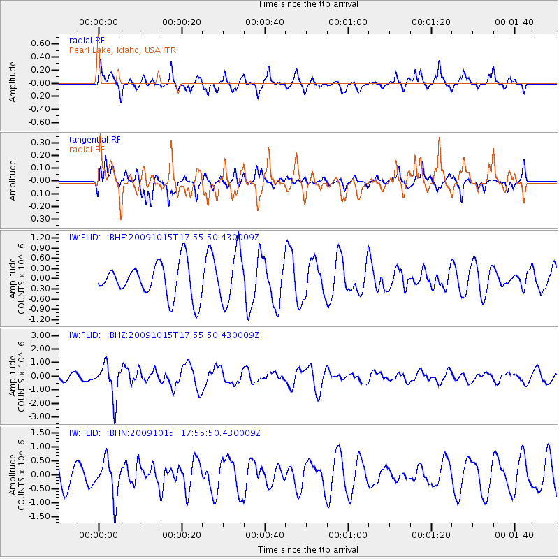
PLID Pearl Lake, Idaho, USA - Earthquake Result Viewer
*The percent match for this event was below the threshold and hence no stack was calculated.
| Earthquake location: |
Galapagos Triple Junction Region |
| Earthquake latitude/longitude: |
3.3/-103.8 |
| Earthquake time(UTC): |
2009/10/15 (288) 17:48:21 GMT |
| Earthquake Depth: |
10 km |
| Earthquake Magnitude: |
5.9 MB, 5.7 MS, 6.0 MW, 6.0 MW |
| Earthquake Catalog/Contributor: |
WHDF/NEIC |
|
| Network: |
IW Intermountain West |
| Station: |
PLID Pearl Lake, Idaho, USA |
| Lat/Lon: |
45.09 N/116.00 W |
| Elevation: |
2164 m |
|
| Distance: |
43.0 deg |
| Az: |
347.343 deg |
| Baz: |
162.013 deg |
| Ray Param: |
$rayparam |
*The percent match for this event was below the threshold and hence was not used in the summary stack. |
|
| Radial Match: |
73.344215 % |
| Radial Bump: |
400 |
| Transverse Match: |
59.565025 % |
| Transverse Bump: |
366 |
| SOD ConfigId: |
2622 |
| Insert Time: |
2010-03-09 07:27:26.416 +0000 |
| GWidth: |
2.5 |
| Max Bumps: |
400 |
| Tol: |
0.001 |
|
Signal To Noise
| Channel | StoN | STA | LTA |
| IW:PLID: :BHZ:20091015T17:55:50.430009Z | 5.2498837 | 1.3028675E-6 | 2.4817075E-7 |
| IW:PLID: :BHN:20091015T17:55:50.430009Z | 1.0104969 | 7.0039016E-7 | 6.931146E-7 |
| IW:PLID: :BHE:20091015T17:55:50.430009Z | 1.5565171 | 7.773767E-7 | 4.9943344E-7 |
| Arrivals |
| Ps | |
| PpPs | |
| PsPs/PpSs | |


