You are here: Home > Network List > IW - Intermountain West Stations List
> Station PLID Pearl Lake, Idaho, USA > Earthquake Result Viewer
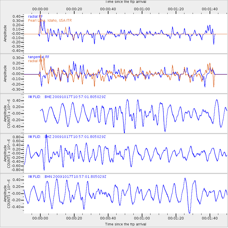
PLID Pearl Lake, Idaho, USA - Earthquake Result Viewer
*The percent match for this event was below the threshold and hence no stack was calculated.
| Earthquake location: |
Samoa Islands Region |
| Earthquake latitude/longitude: |
-16.4/-172.0 |
| Earthquake time(UTC): |
2009/10/17 (290) 10:45:26 GMT |
| Earthquake Depth: |
10 km |
| Earthquake Magnitude: |
5.7 MB, 5.3 MS, 5.7 MW, 5.7 MW |
| Earthquake Catalog/Contributor: |
WHDF/NEIC |
|
| Network: |
IW Intermountain West |
| Station: |
PLID Pearl Lake, Idaho, USA |
| Lat/Lon: |
45.09 N/116.00 W |
| Elevation: |
2164 m |
|
| Distance: |
79.5 deg |
| Az: |
36.674 deg |
| Baz: |
234.036 deg |
| Ray Param: |
$rayparam |
*The percent match for this event was below the threshold and hence was not used in the summary stack. |
|
| Radial Match: |
68.465744 % |
| Radial Bump: |
400 |
| Transverse Match: |
60.07863 % |
| Transverse Bump: |
384 |
| SOD ConfigId: |
2622 |
| Insert Time: |
2010-03-09 07:27:27.255 +0000 |
| GWidth: |
2.5 |
| Max Bumps: |
400 |
| Tol: |
0.001 |
|
Signal To Noise
| Channel | StoN | STA | LTA |
| IW:PLID: :BHZ:20091017T10:57:01.805029Z | 1.8971573 | 4.4883473E-7 | 2.3658276E-7 |
| IW:PLID: :BHN:20091017T10:57:01.805029Z | 1.4056801 | 2.1006397E-7 | 1.4943939E-7 |
| IW:PLID: :BHE:20091017T10:57:01.805029Z | 0.76989675 | 1.5302504E-7 | 1.9876047E-7 |
| Arrivals |
| Ps | |
| PpPs | |
| PsPs/PpSs | |


