You are here: Home > Network List > TA - USArray Transportable Network (new EarthScope stations) Stations List
> Station A36M Sachs Harbour, NT, CAN > Earthquake Result Viewer
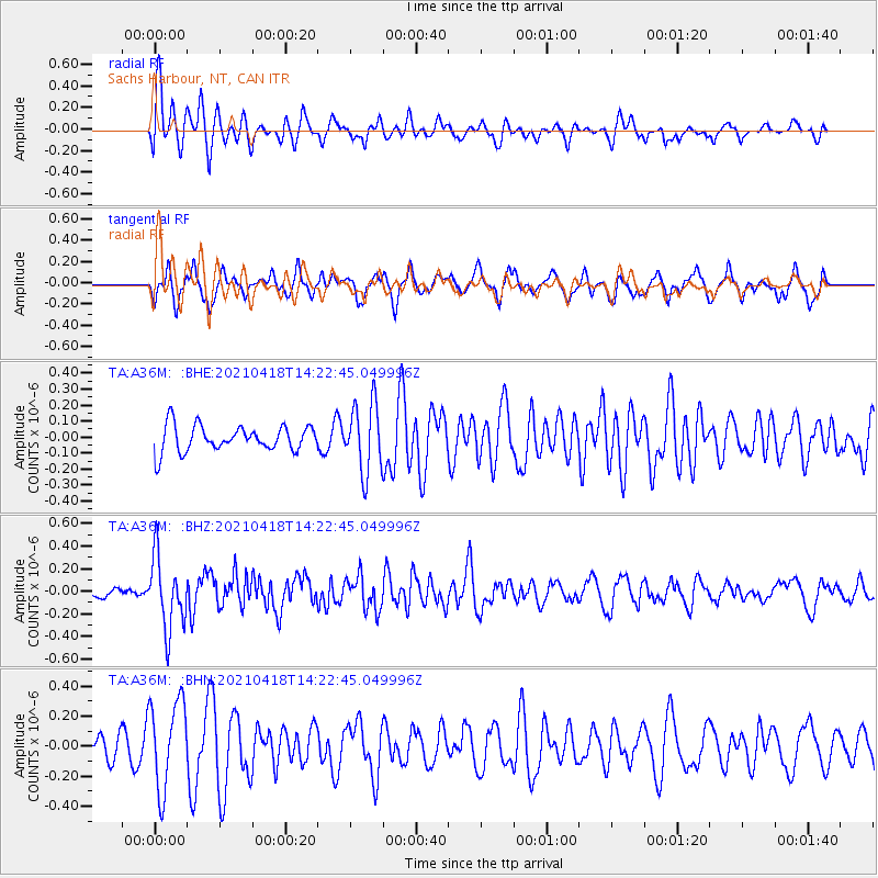
A36M Sachs Harbour, NT, CAN - Earthquake Result Viewer
*The percent match for this event was below the threshold and hence no stack was calculated.
| Earthquake location: |
Taiwan |
| Earthquake latitude/longitude: |
23.8/121.6 |
| Earthquake time(UTC): |
2021/04/18 (108) 14:11:38 GMT |
| Earthquake Depth: |
10 km |
| Earthquake Magnitude: |
5.9 mb |
| Earthquake Catalog/Contributor: |
NEIC PDE/us |
|
| Network: |
TA USArray Transportable Network (new EarthScope stations) |
| Station: |
A36M Sachs Harbour, NT, CAN |
| Lat/Lon: |
71.99 N/125.25 W |
| Elevation: |
32 m |
|
| Distance: |
74.4 deg |
| Az: |
17.274 deg |
| Baz: |
299.045 deg |
| Ray Param: |
$rayparam |
*The percent match for this event was below the threshold and hence was not used in the summary stack. |
|
| Radial Match: |
59.43134 % |
| Radial Bump: |
400 |
| Transverse Match: |
60.765755 % |
| Transverse Bump: |
400 |
| SOD ConfigId: |
24334971 |
| Insert Time: |
2021-05-02 14:28:47.316 +0000 |
| GWidth: |
2.5 |
| Max Bumps: |
400 |
| Tol: |
0.001 |
|
Signal To Noise
| Channel | StoN | STA | LTA |
| TA:A36M: :BHZ:20210418T14:22:45.049996Z | 5.353108 | 3.171975E-7 | 5.9254834E-8 |
| TA:A36M: :BHN:20210418T14:22:45.049996Z | 2.5176275 | 2.961639E-7 | 1.176361E-7 |
| TA:A36M: :BHE:20210418T14:22:45.049996Z | 2.6218908 | 2.131293E-7 | 8.1288405E-8 |
| Arrivals |
| Ps | |
| PpPs | |
| PsPs/PpSs | |


