You are here: Home > Network List > IW - Intermountain West Stations List
> Station PLID Pearl Lake, Idaho, USA > Earthquake Result Viewer
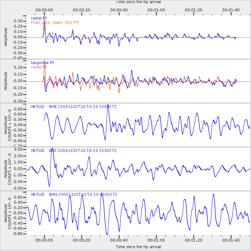
PLID Pearl Lake, Idaho, USA - Earthquake Result Viewer
*The percent match for this event was below the threshold and hence no stack was calculated.
| Earthquake location: |
South Of Tonga Islands |
| Earthquake latitude/longitude: |
-24.1/-175.2 |
| Earthquake time(UTC): |
2009/11/02 (306) 10:47:13 GMT |
| Earthquake Depth: |
9.0 km |
| Earthquake Magnitude: |
6.1 MB, 6.1 MS, 6.2 MW, 6.1 MW |
| Earthquake Catalog/Contributor: |
WHDF/NEIC |
|
| Network: |
IW Intermountain West |
| Station: |
PLID Pearl Lake, Idaho, USA |
| Lat/Lon: |
45.09 N/116.00 W |
| Elevation: |
2164 m |
|
| Distance: |
87.4 deg |
| Az: |
37.512 deg |
| Baz: |
231.758 deg |
| Ray Param: |
$rayparam |
*The percent match for this event was below the threshold and hence was not used in the summary stack. |
|
| Radial Match: |
56.6661 % |
| Radial Bump: |
309 |
| Transverse Match: |
48.91627 % |
| Transverse Bump: |
400 |
| SOD ConfigId: |
2622 |
| Insert Time: |
2010-03-09 07:27:31.368 +0000 |
| GWidth: |
2.5 |
| Max Bumps: |
400 |
| Tol: |
0.001 |
|
Signal To Noise
| Channel | StoN | STA | LTA |
| IW:PLID: :BHZ:20091102T10:59:29.330027Z | 9.700913 | 1.731657E-6 | 1.7850452E-7 |
| IW:PLID: :BHN:20091102T10:59:29.330027Z | 1.5213913 | 2.61196E-7 | 1.7168232E-7 |
| IW:PLID: :BHE:20091102T10:59:29.330027Z | 1.4454577 | 5.39286E-7 | 3.7309013E-7 |
| Arrivals |
| Ps | |
| PpPs | |
| PsPs/PpSs | |


