You are here: Home > Network List > TA - USArray Transportable Network (new EarthScope stations) Stations List
> Station G31M Satah River, YT, CAN > Earthquake Result Viewer
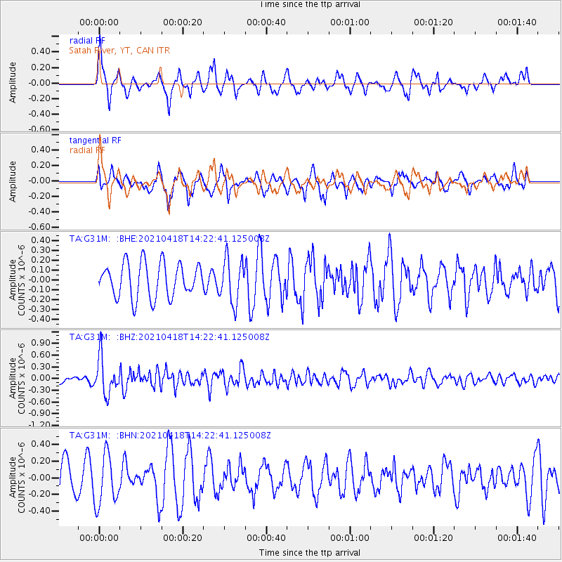
G31M Satah River, YT, CAN - Earthquake Result Viewer
*The percent match for this event was below the threshold and hence no stack was calculated.
| Earthquake location: |
Taiwan |
| Earthquake latitude/longitude: |
23.8/121.6 |
| Earthquake time(UTC): |
2021/04/18 (108) 14:11:38 GMT |
| Earthquake Depth: |
10 km |
| Earthquake Magnitude: |
5.9 mb |
| Earthquake Catalog/Contributor: |
NEIC PDE/us |
|
| Network: |
TA USArray Transportable Network (new EarthScope stations) |
| Station: |
G31M Satah River, YT, CAN |
| Lat/Lon: |
66.92 N/134.27 W |
| Elevation: |
61 m |
|
| Distance: |
73.7 deg |
| Az: |
23.465 deg |
| Baz: |
292.295 deg |
| Ray Param: |
$rayparam |
*The percent match for this event was below the threshold and hence was not used in the summary stack. |
|
| Radial Match: |
65.04944 % |
| Radial Bump: |
361 |
| Transverse Match: |
58.6906 % |
| Transverse Bump: |
322 |
| SOD ConfigId: |
24334971 |
| Insert Time: |
2021-05-02 14:29:30.076 +0000 |
| GWidth: |
2.5 |
| Max Bumps: |
400 |
| Tol: |
0.001 |
|
Signal To Noise
| Channel | StoN | STA | LTA |
| TA:G31M: :BHZ:20210418T14:22:41.125008Z | 4.4453835 | 4.830256E-7 | 1.08657794E-7 |
| TA:G31M: :BHN:20210418T14:22:41.125008Z | 1.4214513 | 3.0692087E-7 | 2.1592076E-7 |
| TA:G31M: :BHE:20210418T14:22:41.125008Z | 1.3089955 | 2.2700357E-7 | 1.7341814E-7 |
| Arrivals |
| Ps | |
| PpPs | |
| PsPs/PpSs | |


