You are here: Home > Network List > TA - USArray Transportable Network (new EarthScope stations) Stations List
> Station N17K Nushagak Hills, AK, USA > Earthquake Result Viewer
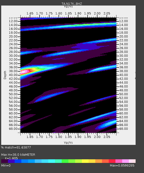
N17K Nushagak Hills, AK, USA - Earthquake Result Viewer
| Earthquake location: |
Taiwan |
| Earthquake latitude/longitude: |
23.8/121.6 |
| Earthquake time(UTC): |
2021/04/18 (108) 14:11:38 GMT |
| Earthquake Depth: |
10 km |
| Earthquake Magnitude: |
5.9 mb |
| Earthquake Catalog/Contributor: |
NEIC PDE/us |
|
| Network: |
TA USArray Transportable Network (new EarthScope stations) |
| Station: |
N17K Nushagak Hills, AK, USA |
| Lat/Lon: |
60.53 N/157.19 W |
| Elevation: |
350 m |
|
| Distance: |
65.3 deg |
| Az: |
32.542 deg |
| Baz: |
274.879 deg |
| Ray Param: |
0.058355294 |
| Estimated Moho Depth: |
38.0 km |
| Estimated Crust Vp/Vs: |
1.61 |
| Assumed Crust Vp: |
6.155 km/s |
| Estimated Crust Vs: |
3.835 km/s |
| Estimated Crust Poisson's Ratio: |
0.18 |
|
| Radial Match: |
81.63877 % |
| Radial Bump: |
357 |
| Transverse Match: |
71.34008 % |
| Transverse Bump: |
353 |
| SOD ConfigId: |
24334971 |
| Insert Time: |
2021-05-02 14:30:10.957 +0000 |
| GWidth: |
2.5 |
| Max Bumps: |
400 |
| Tol: |
0.001 |
|

Signal To Noise
| Channel | StoN | STA | LTA |
| TA:N17K: :BHZ:20210418T14:21:49.349983Z | 9.898526 | 6.862716E-7 | 6.933068E-8 |
| TA:N17K: :BHN:20210418T14:21:49.349983Z | 0.9520678 | 5.5095416E-8 | 5.7869215E-8 |
| TA:N17K: :BHE:20210418T14:21:49.349983Z | 5.0178156 | 3.0705561E-7 | 6.1193084E-8 |
| Arrivals |
| Ps | 3.9 SECOND |
| PpPs | 15 SECOND |
| PsPs/PpSs | 19 SECOND |


